


Inspired by my post from this summer, I decided to start a photographic series of Pittsburgh’s Uptown neighborhood. This neighborhood is a hodgepodge of abandoned and renovated townhomes, parking lots, car-oriented businesses, corner stores, industrial uses, and new construction residential buildings. It is predicted to be on a tipping point from being mostly ignored to experiencing intense growth fueled by activities in and around the neighborhood. These activities include:
As these projects move forward, there will likely be more investment and changes to Uptown. This photographic series is intended to capture these changes by revisiting the same sites at regular intervals over the next several years.
In the coming months, I intend to release two related series to record the progress of the CAP and the Lower Hill redevelopment.
Every year, I look forward to the giant, inflatable dragon airing its wings in Beechview. It is the largest decoration in a small yard overflowing with inflatable ghosts and a giant spider, a witch on a broom, lights, pumpkins, and leaves. Many neighborhoods vie for the best and most prolific displays of Christmas lights. If there were a similar contest for Halloween, this modest-sized house with the dragon seems to me the cream of the crop in a neighborhood with a prolific smorgasbord of Halloween lights and decorations.
This year, I discovered a possible competitor for the title in Shadyside along Pittsburgh’s most intact millionaire’s row. On a lawn that is probably bigger than the footprint of the dragon house is an elaborate, customized ghost wedding. Across the street on a slightly smaller lawn, an 8-10 ft high, gleaming, ceramic clown holds court over a multitude of companions (minions?) of similar sinister and expensive cast.
On seeing these displays, my stomach sank. I felt a loss and a disappointment that this neighborhood may steal the crown for best Halloween decorations due to the unfair advantage of having more disposable wealth. I suppose it really comes down to what is the measure for determining the winning neighborhood: quantity, quality, per capita, density, creativity, or exuberance.
The strongest impression from my last trip to Cardiff was the feeling that it is morally wrong to invest heavily in touristy neighborhoods while skipping the neighborhoods of the residents. Tourists may provide a bigger return per touch point, but residents have many more touch points (including voting). Perhaps I have become jaded since that trip, but I now accept that economics and morals rarely work together.
Pittsburgh’s Uptown neighborhood is trying a different approach to see if economic investment can be leveraged for the greater good. Uptown experienced disinvestment and decay for decades, despite being located between and within walking distance of Oakland and downtown, two of the largest economic engines in the state. Not to mention the main roads connecting these prosperous and growing areas run directly through Uptown. Zipping down Fifth Avenue from Oakland to downtown, it is easy to overlook or ignore the ruined home foundations turning back to forest, the wide-spread vacant lots and parking lots, and the intricate architectural details on the remaining old structures.
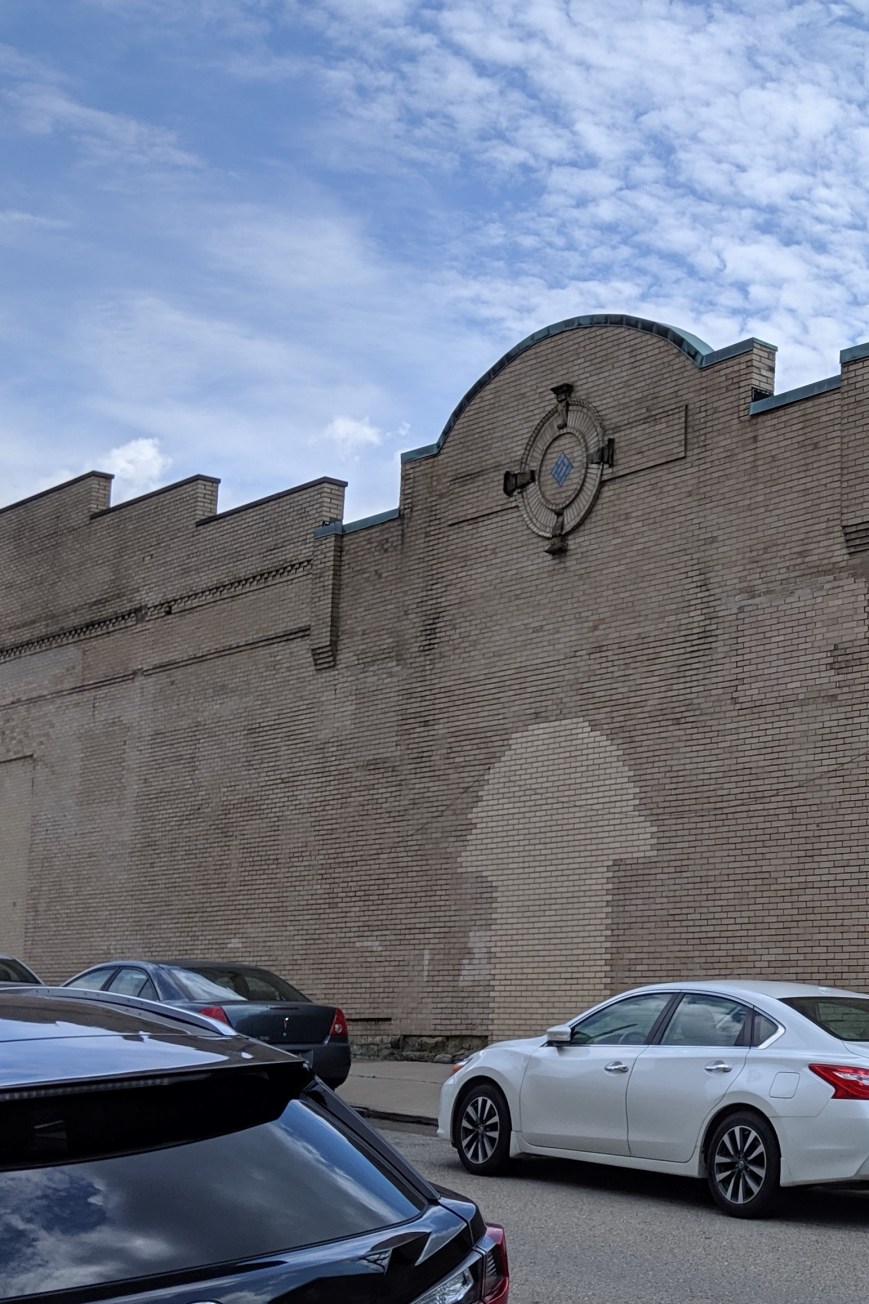
The bland brick and glass facade on Fifth Avenue identifies this building as another mid-century warehouse. Turning the corner, the decorative parapet wall and bricked over arched opening tell the story of an older, more interesting building.
One such structure was one of the many movie theaters dotting the city in the 1920s. In the 1950s, the adjacent buildings were demolished, and an addition was added to the theater to turn it into a storeroom. After a time as a plasma center in the 1980s and 1990s, the building sat vacant and dusty for many years. Now, it is undergoing renovations for its next life. This is just one of the many signs that investment is coming to Uptown.
The community of Uptown that held on through the economically rough times prepared for this moment. In collaboration with many partners, including local institutions such as Duquesne University and UPMC Mercy as well as the City of Pittsburgh, the community created a new neighborhood plan. This designated Uptown and West Oakland as an EcoInnovation District. One of the first actions from this plan developed a new zoning district, the first progressive zoning district in Pittsburgh. The goal of the plan and the zoning district is to leverage the coming economic investment to create an inclusive and environmentally sustainable neighborhood.
It will be interesting to watch this neighborhood over the next few years to see if the plans are successful at introducing some moral components to the economic investment.

I’ve walked numerous bridges and yet I didn’t try building a bridge until my fifth Architectural Dessert Masterpiece. After the near disaster of the skyscraper, this one succeeded beyond my best hopes. With a deck made of shortbread, piers of pretzels, and a non-structural suspension system of wafers and Twizzlers, this one was so structurally sound that it was a challenge to split it into serving pieces.
")
")
I clench my teeth every time the “T”, Pittsburgh’s light rail system, slowly makes the first 90 degree bend leaving Gateway Station, squeaking like fingernails on a chalkboard. After traveling a few hundred yards, it turns back 90 degrees–squeak, scratch, squeak–before pulling into the Wood Street Station. As everyone knows that the shortest distance between two points is a straight line, I struggled to understand why the T was built with turns so sharp it is impossible for the trains not to screech, until my friend pointed out that there might be building foundations or basements that the underground tracks need to maneuver around.
Like many metropolises, the density of downtown Pittsburgh creates various physical layers of activity. Yet compared to other some other cities (see Layers of the City: Chicago Edition), Pittsburgh’s layers can be hard to notice. The T is perhaps the most obvious example. For most of it’s length through the southern neighborhoods and suburbs, the T travels at grade. Once it crosses the Monongahela River into Downtown, it becomes an elevated train for a few blocks before submerging underground until it passes under the Allegheny River to the North Shore, where it reemerges to end as an elevated train.
If you get off the T at Gateway Station and walk down a block to the start of 5th Ave, which actually feels like an alley, you might notice that the Highmark Building is built over an underground garage. I assume that this garage has multiple levels below grade and is at least part of the reason for the T’s sharp turns.
The new PNC Tower also has a garage below grade. Yet the most recent new construction project downtown, on the former site of Sax Fifth Avenue, places the garage between the first floor retail and proposed upper level residences.
The building I work in, the former Jones & Laughlin Steel Mill Headquarters, has at least 3 1/2 levels of basement. The building is long past its days of glory with peeling paint, cracked foundation, and elevators that you may never make it out of again. The mezzanine level of the basement is a maze of building supplies, file cabinets, discarded furniture and boxes upon boxes of documents. It is damp and dusty. Five minutes down there could lead to a severe allergy attack. Yet the stairs keep going down and down, plunging further into the dark depths. I’ve heard rumors of more documents being stored in the lower levels.
Coming back above ground, most activity in downtown Pittsburgh takes place at street level. Pedestrians, bicyclists, buses, cars, delivery trucks, dumpsters, and more compete for space on the narrow streets and sidewalks. Most shopping and restaurants are located at street level. The Highmark Building and the Oxford Building still have some retail above the first floor.
As you walk around downtown, if you look up, you might catch a rare sight of pedestrian sky bridges. The most famous of which is the Bridge of Sighs connecting the Allegheny County Courthouse with the former Jail. The second most famous (speaking with pure bias) is the bridge connecting the parking garage with what used to be the shoe section of the former Kaufmann’s Department Store (always a necessary stop when shopping for back to school). A handful of others are sprinkled throughout downtown. Indianapolis has got us beat though. That city has a network of pedestrian connections that enables you to walk for miles between the stadiums, office buildings, and other structures downtown without ever getting a taste of fresh air.
Higher up, there is a sprinkling of rooftop or penthouse restaurants. This is one of our complaints at work: while many new, good restaurants have opened downtown in recent years, there is still a dearth of restaurants and bars with views. Sienna Mercado’s Il Tetto, Harris Grill, and the Biergarten at Hotel Monaco all have rooftop decks, but they are surrounded by taller buildings limiting views. Ollie’s Gastropub on the top floor of the Oliver Building has some good views, but no fresh air.
There isn’t much connection or relationship between the different parts of these layers in Pittsburgh. It is like they are experiments, like the city is only dabbling. As if to say, it can’t make up its mind whether or not to let the public leave street level and participate in or explore all levels of the city.
It’s the classic story of industry moving on to greener pastures at the same time that suburban flight takes off. Pittsburgh politicians and notables tried everything they could think of to keep the loss of jobs and residents from increasing. Despite their efforts, the city’s population plummeted over the next several decades.
Today, planners and officials often cringe at the mention of the “Urban Renewal” of the 1950s and ’60s. The “bad” judgement applied by their earlier counterparts in efforts to keep the city attractive is an easy scapegoat for the problems of the intervening decades. The people in charge today are doing “good” work by erasing the “mistakes” of the past: tearing down the crime-ridden high rises and replacing them with newly constructed mid-rises and townhomes, returning one-way ring roads to two-way traffic, rebuilding a neighborhood torn down for the sake of a grand civic project only partially deployed, etc.
This rhetoric is seductive. “Urban renewal was evil” is a catchy phrase. It is easy to point the finger and blame what is visible for the effects caused by complicated invisible factors. Yet underneath all this rhetoric and finger pointing there are examples of Urban Renewal success stories in Pittsburgh.
ALCOA is one of Pittsburgh’s highly successful homegrown industrial companies. When it threatened to move its headquarters to New York City in the 1950s, Richard King Mellon and the Mellon Foundation instigated the creation of a package that kept ALCOA in town. ALCOA finally moved its “headquarters” to NYC in 2006, but 11 years later it returned to Pittsburgh. In fact, this was only the executive headquarters with less than 100 staff. ALCOA still continued to have operational headquarters in Pittsburgh throughout that time.
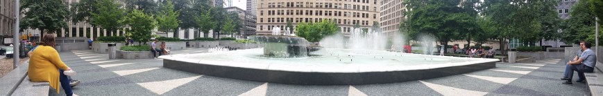
The 1950s package deal that induced ALCOA to stay was a new office building, garage, and public plaza known as Mellon Square. Not only did this succeed in persuading the company to stay, thereby retaining jobs in the heart of downtown Pittsburgh, but the plaza recently underwent a $10 million refresh.
Today, Mellon Square is a gem as an outdoor lunchtime retreat downtown. Unlike Market Square and Mellon Park, it is usually possible even during peak lunchtime to find a seat in Mellon Square, either in the shade of trees or buildings or basking in the sun. Seats near the centerpiece fountain may be wet, especially if it’s a particularly windy day, but there are also seats in more hidden away areas. On different days of the week, there might be a Farmers Market, yoga or other outdoor exercise, or live music to enjoy as well.
When enjoying the ambiance on top, it is easy to forget that there is a parking garage underneath. This garage continues to serve downtown visitors and workers. As the parking levels go down below ground instead of stacking up into the air, it brings less blight to the urban landscape than most other downtown garages. During the 1950s when the idea of car as king was being imprinted in the city’s design through its new ring roads and new Zoning Code, it is amazing to me that Mellon’s team had the insight to say let’s hide the cars out of the way, underground.
In a recent post, I complained about the lack of engaging outdoor spaces in Pittsburgh. I recently realized that I was perhaps a little harsh in that assessment. One of the things that attracted me to Pittsburgh in the first place was the abundance of parks and welcoming open spaces. Now, as a naturalized Pittsburgher, I may take these places too much for granted.
Pittsburgh is home to five large city parks: Emerald View Park, Frick Park, Highland Park, Riverview Park, and Schenley Park. In addition, there are Point State Park, neighborhood parks and playgrounds, and parklets and green spaces.

Downtown has a welcoming outdoor space within a 5 minute walk of almost every office building. Come noon, the most popular ones are out of seats. Some have programming on different days. Market Square and Mellon Square regularly host farmers’ markets, live music, interactive art, and activities.
Yet, these oases are not spread out evenly across the Pittsburgh. East Liberty used to be considered Pittsburgh’s second downtown and was the third largest economic engine in the state. After decades of suburban flight and decay, this neighborhood is experiencing a resurgence that is recapturing much of its former dominance. Yet, when I worked in East Liberty, there were no welcoming outdoor places for me to reasonably get to in my lunch hour. I ended up eating everyday in the office, which meant the only time I left the office between starting and quitting times was when there was an off-site meeting.
It’s not just East Liberty that is missing out on these outdoor pockets and treasures. Much of the city’s riverfronts are still dominated by industry or freeways. Many neighborhood don’t have parks or the ones that are they have not been maintained.
Pittsburgh does have good outdoor spaces, but it could have better. The riverfront is a visible place to expand upon the earlier successes such as Point State Park and the Watersteps. The adult-friendly, public swings which spurred my previous post Engaging Riverfronts is one way to expand upon that. I look forward to more ideas and implementations across the city.

There is an enormous floodwall on the Covington, KY, side of the Roebling bridge, which spans the Ohio River. It shocked me to see such a huge wall when I was there last year. I wondered if there couldn’t have been some other means of flood control that would not have produced such a large barrier. It reminded me of the significant physical barriers to the waterfront that I observed in Erie, Pittsburgh, Homestead, PA, and Cleveland. Unlike Erie, Homestead, and Cleveland, Covington did not have any significant economic drivers separated from the town by the barrier wall. The river side only had a small park and parking lot.


In addition to acting as a barrier, the sheer massiveness of the flat concrete wall bothered me. I wanted to see it broken up into staggered segments, even though I knew that would not be useful in a structure intended to block the path of water. However, Covington handled the flat wall with style by turning it into a canvas for a giant mural. Almost as long as the wall itself, this mural depicts the history of the crossing at this location from 8000 BCE to the present day. While the mural did not help with the scale of the wall, it broke the monotony while turning it into a destination for its own sake.
In the back of my mind, this wall continued to bother me until observing the effects of the significant flooding experienced in Pittsburgh this year at the forks of the Ohio River (see Checking on the Rivers and The Aftermath). A google search showed me that the flooding Pittsburgh experienced in February this year also affected the Covington-Cincinnati region in the worst flood in that area since 1997. The concept of a wall still bothers me, but this one probably prevents a lot of property damage and Covington has taken steps to soften its negative effects.
