The World’s Tallest Church Building

Chicago Temple

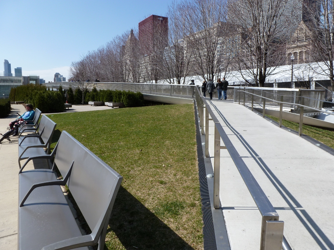
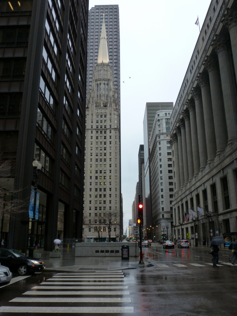
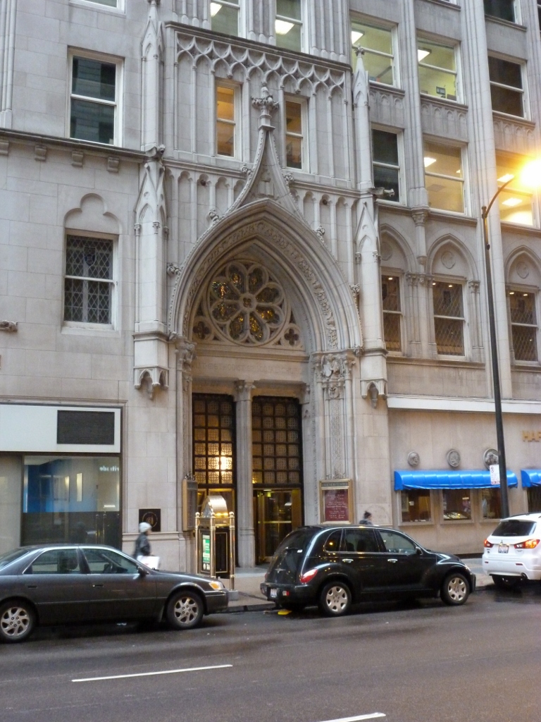
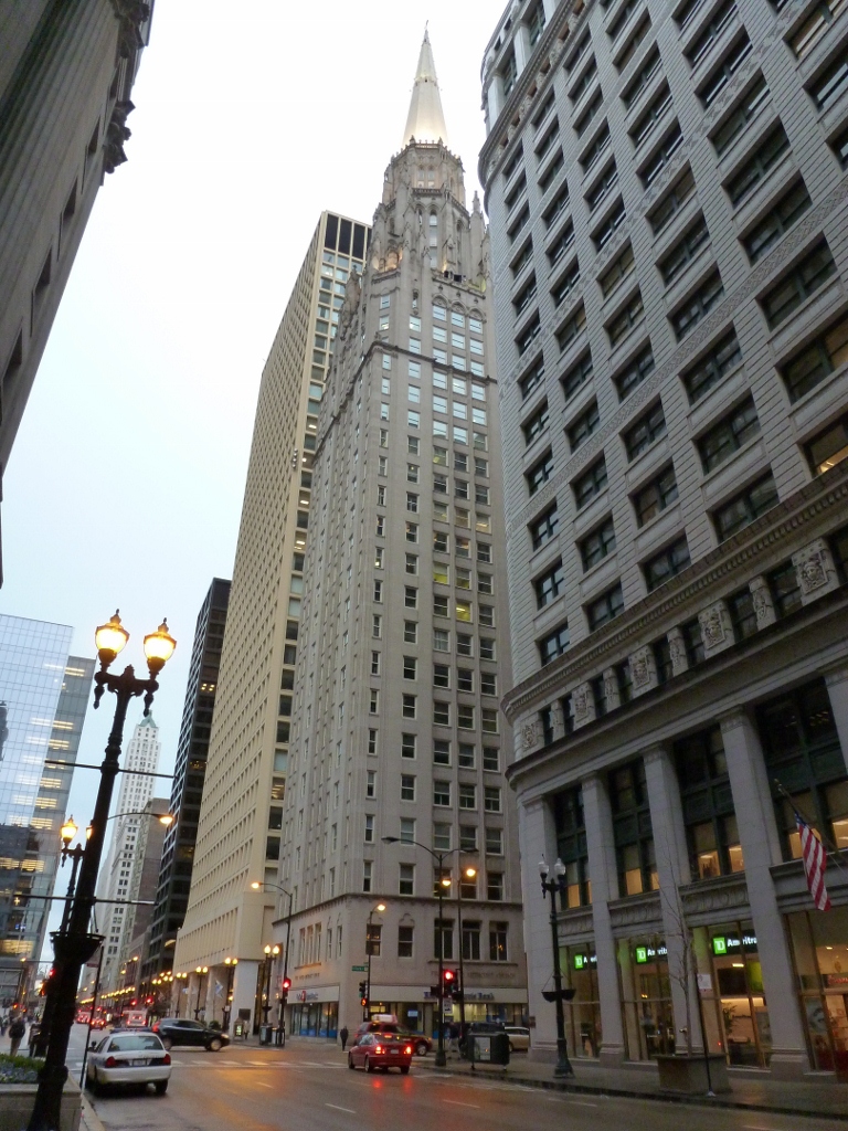
Everything in Chicago is stretched–even churches.  My eye was caught by this building as I looked to cross a street in Chicago and saw the steeple on top of this skyscraper a couple blocks down.  I was very confused at first, trying to figure out why an office building had a steeple on top of it.  Then I saw the name of the church, First United Methodist Church, carved into the side of the building.  The only other indication on the exterior visible from a distance that suggested the religious use of the interior was the doorway.

Chicago Temple Doorway

This building is also known as the Chicago Temple.  The congregation was founded in 1831 and has been worshiping at this site since 1838.  The current building was built in 1924 and has 23 floors.

One of my souvenirs from Chicago was the book “City of the Century” by Donald L. Miller, which describes the history of Chicago up to the 1893 World’s Fair.  So it doesn’t talk about the building of this church building, but it does describe the building of the Auditorium–Chicago’s multipurpose Opera House.  The book notes “there was no government support of the arts in the United States, so the Auditorium would have to pay for itself” (361).  As a result the theater was enclosed in a office/hotel complex.

It seemed like there might have been similar thinking in the design of this church building–as real estate was expensive downtown, covering the church with office space could help it afford its location.  However, if that is why the building is mixed-use, it was not inspired by the Auditorium, which was built in the late 1880s.  According the history page of the church’s website, there has been a multipurpose church building on this site since 1858.  The first one was a 4-story structure with stores and businesses on the first two floors and the church above.

First Methodist Church

The new building has a two-story sanctuary on the first floor.  Accounts differ as to how many this can hold (500, 1000, 1200 people).  The second floor has another smaller sanctuary.  Floors three and four hold the accessory rooms–classrooms, meeting rooms, etc.  The parson’s house is also located in the building.  The remaining floors are office space.  The crowning jewel, is a small chapel underneath the steeple.

I regret that I did not take the time to stop and investigate whether I could explore the inside of the building.  As I was focused on a specific task when I came upon the building, I did not even think about trying to see inside.  If you are interested, I found a YouTube video that shows what I take to be the first floor sanctuary and the small chapel under the steeple.

A Lofty Location

St. John German Evangelical Lutheran Church

This little gem in Pittsburgh’s Lawrenceville neighborhood is full of surprises.  In the 20-some years I’ve been passing through this area, I never noticed the building.  It was brought to my attention a few years ago when I began researching adapted church buildings in Pittsburgh.  If you are in the nearby vicinity, the building blends into its surroundings.  But from other parts of the city it stands out (see 31st Street Bridge, Bloomfield Bridge, Busway Bridges: Herron Street, Busway Bridges: 28th Street).  It is also visible standing out along the ridge in the second photo in my Washington’s Crossing Bridge post.

40th Street Rise

There are two characteristics that make it stand out from a distance.  The first is its location at the highest point on 40th Street in Lawrenceville.

St John's/Choir Loft Condominiums

The second characteristic is one of the most intriguing parts of this building: the fellowship hall is at ground level and the sanctuary is above, reached by a flight of stairs.  This is the only church building I have been in where the sanctuary is a full flight of stairs above ground level.  I’m very curious to know if there are any others–please share, if you’ve come across one!

St John's Evangelical Lutheran Church Choir Loft Condominiums

The building was built in 1896-97 for the German Evangelical Lutheran St. John’s Congregation, which later became St. John’s German Evangelical Lutheran Church.  In 2002, the congregation merged with St. Andrew’s Lutheran Church and closed the doors on this location.  A real estate agent purchased the property and prepped it for conversion into 3 condominiums–one unit each for the sanctuary, fellowship hall, and parish house–before the current owners purchased the property and completed most of the rehab work creating the Choir Loft Condominiums.  (A side note that may be of interest is that the current owners considered purchasing the building that is now the Union Project but chose this one instead.)

The owner reported that the building was essentially empty for nearly 2 years before he acquired it.  The floors were in bad condition–the pews had been ripped out, tearing the sanctuary’s floor, and the choir loft’s floor was completely missing.  He said his goal in renovating the building was to “not destroy the architecture and the interior.  We wanted it to feel like a church still because it is a church.”

Having gotten a tour of the interior of the sanctuary unit, I’d say they succeeded in this goal.  The former sanctuary space is an open loft configuration with hardwood floors.  The raised steps for the altar area were kept and made into the kitchen.  The choir loft remained open and served as the bedroom.  The gorgeous stained glass windows were also intact.  While I was there on a winter evening after sunset, I loved the description of how the colored pattern from the stained glass gradually moves across the floor like a very colorful sundial.  My other favorite part was that there was still a bell in the tower, which the owner rang for me.  While inside the sound was muffled, it sounded like it could have woken sleeping neighbors.

A Picture for Posterity

Meter Row

As I was walking down Penn Avenue this week, I stopped to take this picture before it was gone forever.  Pittsburgh is joining the ranks of cities that use multispace meter systems.  The city’s individual parking meters are slowly disappearing as they are replaced by the multispace system.  Yet even before the transition began, Pittsburgh’s parking meters were suffering.  A complete row of intact meters marching off into the distance, such as those pictured, has been a rare sight in the city for years.  Usually there are at least a few with their heads chopped off or their stalks bent.  On close inspection, this row did have graffiti on many of the heads and at least one meter was out of order.  However, in the spring sunshine, these meters looked almost pristine with their gold heads gleaming.

PGH’s Expanding Bicycle Infrastructure

The Green Bike Lane

This week was an exciting one for bike infrastructure in the city of Pittsburgh.  The first green bike lane was installed.  I’ve been waiting for this for two years and it surpassed my expectations! (I am sure others, such as the city’s Bike Planner who brought the project about, waited for this moment much longer me.)

Installing the Green Bike Lane

The road here used to be three lanes (left-turn only and two straight), but the right lane was rarely used because just after the next intersection it merges into the left lane.  The lines for the green bike lane were painted late last fall, but I assume the green wasn’t laid then due to weather issues.  As I passed through this area regularly on the bus, I noticed that there were some motorists who either ignored the solid line running along the side and down the middle of the lane or didn’t notice them.  This lane did not have the bike symbol in it yet, so I motorists being a little confused here.  However, in other parts of the city, I have often witnessed cars driving along in clearly designated bike lanes (meaning there are signs posted and the bike symbol painted in the road).  Soon I hope to be able to report that motorists recognize they don’t belong where the green paint is, giving bikers a clearly recognized portion of the road.

Green stands out

One of the really neat things about this bike lane is that it stands out from quite a distance.  I was initially skeptical when I heard it was going to be a green lane–I pictured a grass or forest green color–but this neon green is very eye catching.

Gingerbread Blue Mosque

Gingerbread Blue Mosque Blue Mosque

Figuring out how to design an accurate representation of the Parthenon out of cake and cookies (see post) was an intriguing task that set me on a new hobby of designing models of existing buildings out of deserts.  Beginning with my second Architectural Dessert Masterpiece, all my creations are based on buildings/structures that I have personally encountered in my urban explorations.

I created my second desert building in December 2011.  While eating the Parthenon the previous year, suggestions were put out about how to create other shapes and buildings such as using jello and creating round shapes.  I was particularly engaged by the idea of how to create a dome.  I had not figured out how to create a dome such as those on capital buildings in the US, but I thought I could create one that would be close to those on the mosques I visited in Istanbul.  I chose the Blue Mosque as a visually interesting structure that would require a diversity of desserts to create.

Gingerbread cookies seemed to be the best way to design the frame of the building given the variety of heights and shapes of the building.  I used sugar cookies for the larger domes and half domes.  I knew someone growing up who was able to create perfectly rounded sugar cookies, no matter how I try I have never been able to create the same effect.  My sugar cookies worked well for the medium-sized domes, but I had to put two cookies together for the larger domes.  M&Ms made great small domes–they were also the base unit that determined the scale of my model.  I think another reason why I chose to create a mosque was so I’d have an excuse to use the Pirouette cookies again, this time as minarets.  I love these cookies, but hardly ever get them.  Using my piping set, I was able to create pointed tops on the minarets and add balconies.

This was by far the most time-consuming Architectural Dessert Masterpiece to create (at least of the four I’ve made so far) because of having to design the required sizes and shapes for the gingerbread cookies and cutting them out and then also baking sugar cookies, which somehow always takes forever.  I also played with “whitewashing” the gingerbread walls, but the method I tried didn’t create the desired effect so I gave up on it.

Eating Architectural Dessert Masterpieces is also an interesting experience, as they often require creative thinking to destruct them.  With the Parthenon, I employed a karate-chop method for cutting through the wafers.  On the other hand, with the Blue Mosque a free-for-all of pulling it apart with your fingers seemed most appropriate.

Gingerbread Blue Mosque Blue Mosque

Parthenon Cake

Parthenon Cake

My hobby of creating Architectural Desert Masterpieces began about three years ago, when I was an AmeriCorps volunteer.  Searching for activities to do with my kindergartners in the after-school program, I somehow came across a recipe for making an Ancient Temple Cake.  While this was not at all feasible to do with my students, I thought it was an awesome idea and saved the recipe to try one day.

The following December, I decided it was time to try the Ancient Temple Cake.  By that point I was back in school and had taken a history of Western Architecture course, which included detailed discussions of ancient temples including the Parthenon.  When I pulled out the recipe, I decided it needed some improvements to make it a reasonable imitation of the Parthenon.  The directions were to bake a sheet cake, frost it, stick Pirouette cookies around the edge and top the Pirouettes with wafer cookies.  However, from my architecture course I knew that proportions were important as were the steps up to the temple.

I created a step to the temple but cutting off the edges, cutting them in half (height-wise) and reattaching the bottom halves to the cake body with frosting.  Then I added a number of Pirouette cookies based on the proportion of columns on the long and short sides of the Parthenon.  When I was done, I had a much better representation of the Parthenon in cake form than the recipe I started with.

Unfortunately, my cake temple aged rather quickly resulting in the collapse of the columns on one side.

Ruined Parthenon Cake

Pedestrian Bridges: Chicago

BP Bridge

There are two pedestrian bridges connecting to Millennium Park in Chicago.  The first I encountered was the BP Bridge.  I admired the undulating silver sculpture above as I walked past and was thrilled to discover it was a pedestrian bridge.  My excited was quickly crushed as the bridge was closed to traffic due to construction at the other end.  I realized that I have become quite addicted to bridge-walking.  I was on my way to see The Bean before renting a bike to ride along the lake, when seeing this bridge completely sidetracked me.  I had a desperate urge to walk a bridge.  Fortunately, there was another pedestrian bridge nearby and while it was not nearly as enticing, it had some interesting parts.

BP Bridge The Nichols Bridgeway

The Nichols Bridgeway connects Millennium Park with the Art Institute of Chicago.  Both ends had space-age-like toughs, which I assumed were supposed to be a fancy drainage system.  If their purpose is a drainage system, the upper end by the Institute has failed and been turned into a wishing well.

Lower Trough Upper Trough/Wishing Well

The part I liked best about this bridge was that while it looked like the surface was level, there were ridges or “speed-bumps” every few feet.  I wondered if these were merely artistic or if they had a functional value like reducing the slipperiness of the bridge during icy conditions.

Bumpy Walkway The Nichols Bridgeway

What is a Bridge? Chicago Edition I

Stetson Ave, Chicago, from the Hyatt

In July 2012, a few months into the height of my Pittsburgh bridge-walking, I pondered the definition of a bridge in What is a Bridge? Pittsburgh Edition I and What is a Bridge? Pittsburgh Edition II.  Asking what a bridge is may seem a little odd.  After all, it’s one of those things that you know it when you see it, right?  Yet, in walking bridges, I’ve discovered it really isn’t that simple.  In everyday life, the actual semantics of what a bridge is, is not important–you either cross it or you don’t and move on with your life.  But if you’re trying to walk as many Pittsburgh bridges as you can (as I am) or to count the number of bridges a city has to see which has the most of any city in the world (as others have), spelling out a clear definition of a bridge becomes important.  By the end of my previous posts on the definition of a bridge, it seemed like I had covered almost all the difficulties: is a bridge still a bridge if it no longer bridges anything? what’s the difference between a bridge and a ramp? how many is one bridge?….but then I went to Chicago and faced a new facet to this problem.

The issue Chicago brings up is best illustrated by the image above.  Is there a bridge in that picture?….No, right?….Try again.  If you walk past the buildings on the right, you get a new perspective on the seemingly solid ground you stand on (pictured below).

Discovering Ground Level on Stetson Ave
Looking Back Toward Hyatt on Stetson

Walking around on this street and the blocks around it, you may notice metal joints like those normally found only in bridges running across the roads and sidewalks.  You may also feel the ground bounce like a bridge as a large truck drives by.

Metal Joints across road and sidewalk on Michigan Ave
Metal joint across road on Columbus Drive

Are these roads, then, really bridges?  If no, what are they?  If yes, where does one bridge end and the other begin?  For example, is the Michigan Avenue Bridge across the Chicago River, visible in the back left of the image above-left, just a continuation of the Michigan Avenue road-bridge or is it a separate bridge?


Additional Posts in Series:

Manhattan Bridge: A Multimodal Link

The Manhattan Bridge

When I was planning my walk across the Brooklyn Bridge while in New York City last December, I noticed there was a bridge nearby called the Manhattan Bridge.  I decided to cross to Brooklyn by the Manhattan Bridge and return to Manhattan by the Brooklyn Bridge.  The Manhattan Bridge ended up being the more interesting of the two bridges.

Gateway to the Manhattan Bridge

I found my way from the subway stop to the Manhattan Bridge by following the way-finding signs for the bike lanes in the Lower East End.   This brought me to the left side of the bridge, where I was temporarily upset to see that pedestrians were not permitted to use the sidewalk on that side of the bridge–it was dedicated to two-way bicycle traffic.  I was concerned that I was not going to be able to walk across this bridge and instead would have to cross the Brooklyn Bridge twice (I try to avoid walking across a bridge just to walk back across it; doing so gives me a sense of pointlessness).  Luckily, there are sidewalks on both sides of this bridge (from walking Pittsburgh bridges I know not to assume that bridges have sidewalks on two sides) and the sidewalk on the right side is dedicated to pedestrians.

I suggest that NYC puts up a sign on the bicycle side to direct pedestrians to the other side, which might help encourage pedestrians to follow the traffic directions set up on this bridge–I watched a pedestrian ignore the bicycle-only signs to cross the bridge on the bike lanes.

The Pedestrian Side

This bridge is the most multimodal bridge I have walked with the bike lanes on one side, pedestrian way on the other, and the subway and roadway in between.  While I approve of this welcoming of alternative transportation methods, I am not sure about placing the pedestrians next to the subway tracks.  This does give a barrier between the pedestrians and the noise of the cars, but instead, the pedestrians have to deal with the noise of the subway, which while it is less constant than the cars, it is a little more startling/disturbing.

The Manhattan Side The Brooklyn Bridge

The neighborhoods the Manhattan Bridge links had some similar physical elements, but are clearly used by different populations.  The populations on both the Manhattan and Brooklyn sides use their rooftops, but for different purposes.  On the Manhattan side, the rooftops were covered in graffiti, while the Brooklyn rooftops had new additions and places to sit.  There were also parks on both sides of the East River.  However, the Manhattan side only had a baseball diamond while the Brooklyn side had a carousel and a pirate-ship playground.

Manhattan side park

Carosel Pirate Ship Playground

What intrigues me most about the Manhattan Bridge is that I had never seen or heard of it before and yet it is the bridge shown in the background (multiple times) in the Doctor Who episode “The Angels Take Manhattan.”  Based on my walk on the Brooklyn and Manhattan Bridges, it looks like these shots were taken on the Brooklyn side of the river, in which case it seems like it possible to get the Brooklyn Bridge in the background instead as these two are close together on that side.  To me the images of the Brooklyn Bridge say New York, while (at least before I walked it) images of the Manhattan Bridge just say a place with a bridge and hence water.  I wonder if the Manhattan Bridge is better known in the UK than in my circle?

View like that used in Doctor Who