
Pittsburgh DinoMite Parade 7

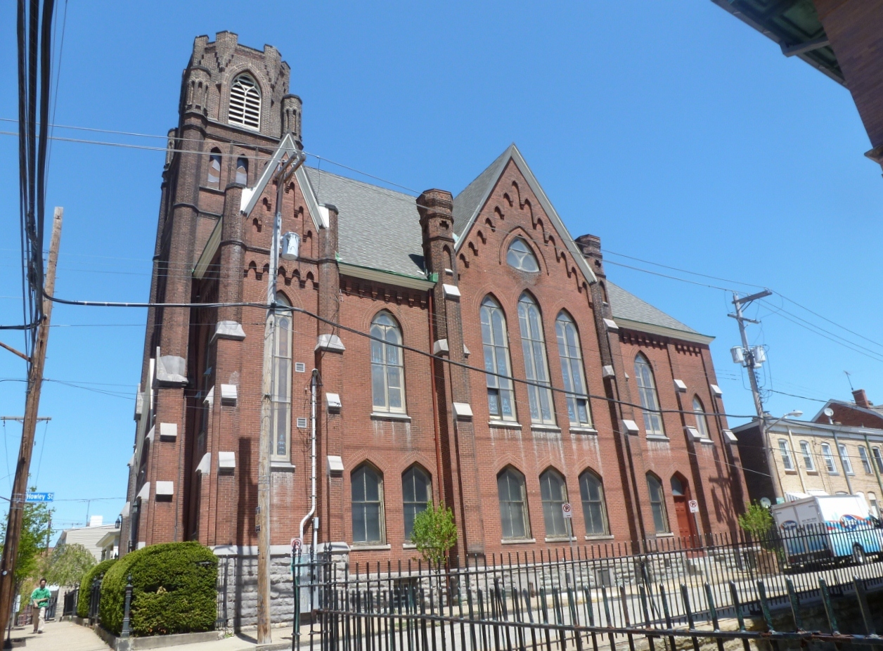
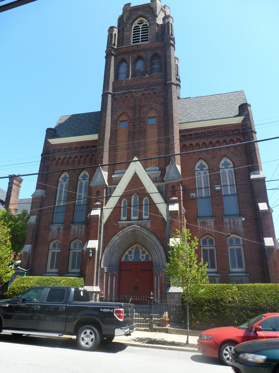
This little gem in Pittsburgh’s Lawrenceville neighborhood is full of surprises. In the 20-some years I’ve been passing through this area, I never noticed the building. It was brought to my attention a few years ago when I began researching adapted church buildings in Pittsburgh. If you are in the nearby vicinity, the building blends into its surroundings. But from other parts of the city it stands out (see 31st Street Bridge, Bloomfield Bridge, Busway Bridges: Herron Street, Busway Bridges: 28th Street). It is also visible standing out along the ridge in the second photo in my Washington’s Crossing Bridge post.

There are two characteristics that make it stand out from a distance. The first is its location at the highest point on 40th Street in Lawrenceville.
The second characteristic is one of the most intriguing parts of this building: the fellowship hall is at ground level and the sanctuary is above, reached by a flight of stairs. This is the only church building I have been in where the sanctuary is a full flight of stairs above ground level. I’m very curious to know if there are any others–please share, if you’ve come across one!

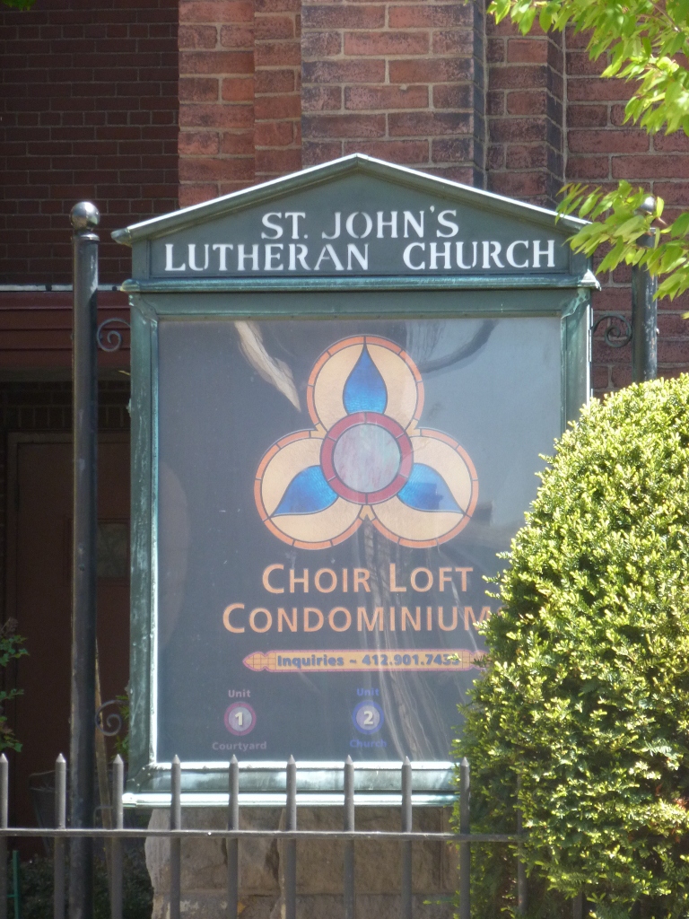
The building was built in 1896-97 for the German Evangelical Lutheran St. John’s Congregation, which later became St. John’s German Evangelical Lutheran Church. In 2002, the congregation merged with St. Andrew’s Lutheran Church and closed the doors on this location. A real estate agent purchased the property and prepped it for conversion into 3 condominiums–one unit each for the sanctuary, fellowship hall, and parish house–before the current owners purchased the property and completed most of the rehab work creating the Choir Loft Condominiums. (A side note that may be of interest is that the current owners considered purchasing the building that is now the Union Project but chose this one instead.)
The owner reported that the building was essentially empty for nearly 2 years before he acquired it. The floors were in bad condition–the pews had been ripped out, tearing the sanctuary’s floor, and the choir loft’s floor was completely missing. He said his goal in renovating the building was to “not destroy the architecture and the interior. We wanted it to feel like a church still because it is a church.”
Having gotten a tour of the interior of the sanctuary unit, I’d say they succeeded in this goal. The former sanctuary space is an open loft configuration with hardwood floors. The raised steps for the altar area were kept and made into the kitchen. The choir loft remained open and served as the bedroom. The gorgeous stained glass windows were also intact. While I was there on a winter evening after sunset, I loved the description of how the colored pattern from the stained glass gradually moves across the floor like a very colorful sundial. My other favorite part was that there was still a bell in the tower, which the owner rang for me. While inside the sound was muffled, it sounded like it could have woken sleeping neighbors.

The 28th Street Bridge is one of Polish Hill’s two points of access to the lower regions between it and the Allegheny River, the second is the Herron Street Bridge (see post). This bridge is also the last pedestrian accessible bridge across the busway before downtown. Several of the views from this bridge are similar to, but better than, the ones from the Herron Street Bridge.


For instance, the images of downtown from the 28th Street Bridge have fewer non-downtown buildings blocking the view than those from the Herron Street Bridge.

Also, the Children’s Hospital and Choir Loft Condominiums are visible from both bridges, but on the Herron Street Bridge only the tops of the buildings were visible while from the 28th Street Bridge most of the buildings are visible.

Across the river in Troy Hill, another site of contention within the city is visible. The former St. Nicholas Church pictured above is the sister to the St. Nicholas Church I saw from the 40th Street Bridge (see post), has been vacant since 2004, and has been locked in a battle between preservationists and the parish for over a year. The parish wants to demolish the building that it cannot afford to maintain and many people have called an eyesore, while the preservationists want to preserve the building. This summer a county judge ruled in favor of the parish (see article), but the city has threatened to appeal this decision (see article). The building is certainly architecturally interesting, however it is in a horrible location, smack up against route 28, which I believe provides the only access to the building.

Earlier this summer, when I was talking with someone about my project to walk the bridges of Pittsburgh, he asked me which bridge was my favorite so far. I hadn’t thought about it before, but when he asked, I decided that the Heth’s Run Bridge was my favorite because its design and its existence called up many questions (see May 31 and June 9 posts). Now I would say that the 28th Street Bridge is my favorite, despite the fact that it is rusting, the sidewalk is crumbling, and it has the cage-like fence I generally dislike. I think the bridge is rather cute (if a bridge can be called cute)….Or perhaps I like it so much because it has a stone-lined approach. I love stone.


Polish Hill, the neighborhood which is home to the Immaculate Heart of Mary’s Church I’ve pointed out in some posts (see 31st Street Bridge and A Sidewalk to Nowhere), has only two points of access to the lower ground along the Allegheny River. These are the Herron Avenue Bridge (above) and the 28th Street Bridge (see post) which cross over the busway and parallel railroad tracks to reach Lawrenceville and The Strip District, respectively.

There are a few sites of interest from the Herron Avenue Bridge. The first of which is the former Iron City Brewery site, which up until a few years ago was the oldest (and only remaining) brewery within the city limits. It closed and the site has been vacant ever since. This summer, it became a site of contention. The property was purchased earlier in the year by a development company, who this summer demolished some of the buildings on the site. The site is a designated historic landmark, but the company received permission to demolish one building that was structurally unsound. As I read it in articles in the Post-Gazette and elsewhere, the company said that when this building was demolished others became unstable requiring immediate demolition. The Lawrenceville Stakeholders Historic Preservation Committee petitioned the city to site the company for unauthorized demolitions. At the end of August, the development company was fined $20,000 for the demolitions (see article). Despite the argument over the demolitions, the company and the neighborhood are supposedly working together to come up with a plan to (re)develop the site.


Also visible from the bridge are two of Pittsburgh’s repurposed churches. The one in the first picture is the Church Brew Works, the city’s most infamous adaptive reuse of a church building. The one in the second picture is the Choir Loft Condominiums which have been visible from other bridges as well (see Bloomfield Bridge and 31st Street Bridge posts).
Other views from this bridge show downtown and the busway.


Baum Boulevard and Centre Ave run parallel along the border of Pittsburgh’s Shadyside and Bloomfield neighborhoods and are arteries that help people move from downtown and Oakland to East Liberty and other East End neighborhoods. The Baum-Centre corridor is currently receiving a lot of attention from the perspective of the development of the city. There is even a community group called the Baum-Centre Initiative made up of representatives from other groups along the corridor. Their goal is to work together to promote development along the corridor that is beneficial and satisfactory to their respective groups and communities.
This area is attracting interest in part because of its arterial activity, but also because Baum used to be the car dealership district. Most of the dealerships have closed their locations leaving behind many empty buildings. Contrary to this disinvestment, Centre Ave hosts one of the UPMC hospitals and an urgent care center was recently added. From what I’ve picked up, UPMC is working to expand in this area.

The large building between Centre and Baum last housed a party/costume supply store, but I image most of the building was sitting empty. For about the last year, it has been under redevelopment. The rumor I have heard is that something related to UPMC is going into the space.
I also heard that UPMC wants to build a parking lot for its employees in this area. I couldn’t picture exactly where it was to be placed from the description I heard, but I wonder if it is this empty lot off of Baum Boulevard.
Outside of the developments going on near them, my impression of these two bridges is that they are quite ugly. I am glad that except for when I walked them for my project, I’m in a bus when crossing Centre Avenue’s bridge and in a car when crossing Baum Boulevard’s bridge. Now that I mention it, that’s how I felt about most of the bridges across the busway I’ve walked (except for the new pedestrian bridge, see July 26 post). Though I haven’t written the posts for all of them yet, at this point I have walked all the bridges over the busway between Penn Avenue and the Bloomfield Bridge.


My favorite part about walking these two bridges was the view of Bloomfield/Lawrenceville from the Baum Boulevard Bridge. This view captures two of Bloomfield’s churches (both currently active) with Lawrenceville’s Childrens Hospital sandwiched between them.


To date I have walked the 31st Street Bridge twice. The first time was a few years ago when I had over two hours to kill between an event downtown and a meeting in the Strip a few blocks from the bridge. So I naturally decided to spend it by walking from the first to second location along the Three Rivers Heritage Trail. It was winter and I saw the first flurries of the season as I crossed this bridge. For that reason, I remember the walk and the bridge fondly though I was disappointed and surprised when I arrived at the Strip District end of the bridge to realize how far away I was from the stores in the Strip. I had been planning on getting a snack at one of the nice little ethnic groceries or perhaps at the bakery. As I was in a car every other time I had been to the Strip, I never realized how little of the neighborhood the stores took up. Fortunately, there was hot chocolate and a good spread of fruit and pastries at my meeting.
As I sat down to write this post, I realized that I have already discussed most of the observations I had or at least something similar in other posts. So I went to PGHbridges.com to look for some inspiration of something new to write. It has a nice description of the decorations on the bridge (see link), which I completely missed as I walked it this summer either because they aren’t there or because I looked in the wrong places as I thought there might be some decoration. The other thing that intrigued me on the website was the name of the bridge which is 31st Street Bridge, Number Six Allegheny River. I thought perhaps this meant it was the sixth bridge at this location; however PGHbridges.com says that the 31st Street Bridge replaced a former bridge at 30th Street. While the streets aren’t that far apart, it seems more likely that “number six” refers to it being the sixth bridge up the Allegheny from the Point, yet this would have to be only counting road bridges (not railroad). The 1929 G.M. Hopkins map shows that the sixth bridge from the point is the 16th Street Bridge when you count the railroad bridge between the 9th and 16th Street bridges.


These are the pictures that go with the topics I’ve discussed in other posts. On the left is the cookie-cutter, perfectly manicured housing development on Herr’s Island. In my Converted Railroad Bridge post, I mention how I feel like a trespasser when I walk through this part of the island. Except for the little lighthouse/widow’s walk attachments on top of the houses (the circular, red peaked roof thing), the development looks identical to some of the newer developments (older being 1960s) in the California town I lived in for several years.
The view downriver, above on the right, shows again the two clusters of tall buildings downtown that I first observed on the 16th Street Bridge (see July 13 post).


Several well-known landmarks (which I have mentioned in other posts) are visible from the 31st Street Bridge. First on the downstream side (above left) is the Immaculate Heart of Mary Church. Perhaps because of the lighting and angle, I don’t think it appears as impressive in the picture as it does in real life. I mentioned this landmark previously in my post about the Fort Duquesne Bridge. On the other side of the bridge (above right), the most famous landmark is Children’s Hospital, which came up in the 9th Street Bridge post. Before doing this project, I don’t think I realized just how big Children’s Hospital is. I thought it was big, but I’ve learned from observing it from the 9th and 31st Street bridges that it is actually huge. Closer to the bridge a little lower on the hill from the hospital is the St. Augustine Church in Lawrenceville, one of the many large, old, and beautiful churches in the city. I’d also like to point out the little church on the right-hand side of the photo towering above its surroundings. I don’t want to go into much detail about it now, but it is one of Pittsburgh’s repurposed churches and I will be coming back to it in a future post.

I decided to address each of the Three Sisters separately after all and for some reason to do it out of order (which is quite unusual for me as I am generally very methodical). The 9th Street Bridge is also called the Rachel Carson Bridge. Rachel Carson was an environmentalist who grew up near Pittsburgh and attended college at the forerunner of Chatham University (one of Pittsburgh’s many universities). The bridge was named in her honor on Earth Day in 2006. Unlike the other Three Sisters Bridges, there is no specific reason why this bridge should have been named for Rachel Carson. The 6th Street Bridge (see June 14th post) renamed for Roberto Clemente, a former Pirates player, connects to PNC Park, the current home of the Pittsburgh Pirates, while the 7th Street Bridge renamed for Andy Warhol connects to the Andy Warhol Museum (see June 22 post). As far as I am aware, there is no similar connection between the location of the 9th Street Bridge and its namesake.
As far as my observations go, this bridge is the least used of the Three Sisters. The south end of the bridge is near CAPA High School (for performing arts) and the Convention Center, but the north end does not connect to any buildings or sights that seem like they attract much traffic, while the north end of the other two connect to a museum and a ballpark. In addition to the surroundings, the condition of the bridge suggested that it is not as well cared for (perhaps because there is less traffic) than the others. There are two stone pillars at each end of each of the three bridges. One of these on the Rachel Carson Bridge was almost completely covered in vines and weeds. The side facing into the bridge holds the plaque identifying the bridge and was the only side not covered in growth. On second thought, perhaps this is not due to a lack of maintenance but rather in recognition of the fact that Rachel Carson was an environmentalist.

The views up and downriver from the Rachel Carson Bridge encompass mostly the other bridges around it. Upriver are a railroad bridge, the Veteran’s Bridge (see June 24 post), and the 16th Street Bridge (see July 13 and July 14 posts). However, rising above these bridges is the Children’s Hospital in Lawrenceville, another iconic Pittsburgh building visible from multiple points around the city and displaying a color scheme as intriguing as any of the London bridges.

