Park-ing

It’s the classic story of industry moving on to greener pastures at the same time that suburban flight takes off.  Pittsburgh politicians and notables tried everything they could think of to keep the loss of jobs and residents from increasing.  Despite their efforts, the city’s population plummeted over the next several decades.

Today, planners and officials often cringe at the mention of the “Urban Renewal” of the 1950s and ’60s.  The “bad” judgement applied by their earlier counterparts in efforts to keep the city attractive is an easy scapegoat for the problems of the intervening decades.  The people in charge today are doing “good” work by erasing the “mistakes” of the past: tearing down the crime-ridden high rises and replacing them with newly constructed mid-rises and townhomes, returning one-way ring roads to two-way traffic, rebuilding a neighborhood torn down for the sake of a grand civic project only partially deployed, etc.

This rhetoric is seductive.  “Urban renewal was evil” is a catchy phrase.  It is easy to point the finger and blame what is visible for the effects caused by complicated invisible factors.  Yet underneath all this rhetoric and finger pointing there are examples of Urban Renewal success stories in Pittsburgh.

ALCOA is one of Pittsburgh’s highly successful homegrown industrial companies.  When it threatened to move its headquarters to New York City in the 1950s, Richard King Mellon and the Mellon Foundation instigated the creation of a package that kept ALCOA in town.  ALCOA finally moved its “headquarters” to NYC in 2006, but 11 years later it returned to Pittsburgh.  In fact, this was only the executive headquarters with less than 100 staff.  ALCOA still continued to have operational headquarters in Pittsburgh throughout that time.

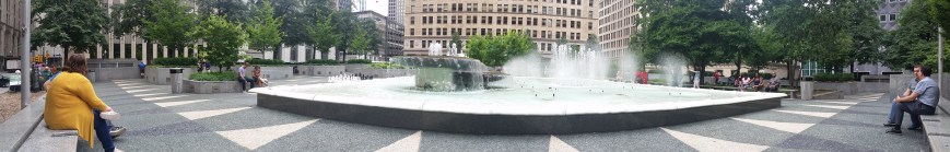
The 1950s package deal that induced ALCOA to stay was a new office building, garage, and public plaza known as Mellon Square.  Not only did this succeed in persuading the company to stay, thereby retaining jobs in the heart of downtown Pittsburgh, but the plaza recently underwent a $10 million refresh.

Today, Mellon Square is a gem as an outdoor lunchtime retreat downtown.  Unlike Market Square and Mellon Park, it is usually possible even during peak lunchtime to find a seat in Mellon Square, either in the shade of trees or buildings or basking in the sun.  Seats near the centerpiece fountain may be wet, especially if it’s a particularly windy day, but there are also seats in more hidden away areas.  On different days of the week, there might be a Farmers Market, yoga or other outdoor exercise, or live music to enjoy as well.

When enjoying the ambiance on top, it is easy to forget that there is a parking garage underneath.  This garage continues to serve downtown visitors and workers.  As the parking levels go down below ground instead of stacking up into the air, it brings less blight to the urban landscape than most other downtown garages.  During the 1950s when the idea of car as king was being imprinted in the city’s design through its new ring roads and new Zoning Code, it is amazing to me that Mellon’s team had the insight to say let’s hide the cars out of the way, underground.

Growing Parks

20180807_122605 copy

In a recent post, I complained about the lack of engaging outdoor spaces in Pittsburgh.  I recently realized that I was perhaps a little harsh in that assessment.  One of the things that attracted me to Pittsburgh in the first place was the abundance of parks and welcoming open spaces.  Now, as a naturalized Pittsburgher, I may take these places too much for granted.

Pittsburgh is home to five large city parks: Emerald View Park, Frick Park, Highland Park, Riverview Park, and Schenley Park.  In addition, there are Point State Park, neighborhood parks and playgrounds, and parklets and green spaces.

20180807_122530 copy

Downtown has a welcoming outdoor space within a 5 minute walk of almost every office building.  Come noon, the most popular ones are out of seats.  Some have programming on different days.  Market Square and Mellon Square regularly host farmers’ markets, live music, interactive art, and activities.

Yet, these oases are not spread out evenly across the Pittsburgh.  East Liberty used to be considered Pittsburgh’s second downtown and was the third largest economic engine in the state.  After decades of suburban flight and decay, this neighborhood is experiencing a resurgence that is recapturing much of its former dominance.  Yet, when I worked in East Liberty, there were no welcoming outdoor places for me to reasonably get to in my lunch hour.  I ended up eating everyday in the office, which meant the only time I left the office between starting and quitting times was when there was an off-site meeting.

It’s not just East Liberty that is missing out on these outdoor pockets and treasures.  Much of the city’s riverfronts are still dominated by industry or freeways.  Many neighborhood don’t have parks or the ones that are they have not been maintained.

Pittsburgh does have good outdoor spaces, but it could have better.  The riverfront is a visible place to expand upon the earlier successes such as Point State Park and the Watersteps.  The adult-friendly, public swings which spurred my previous post Engaging Riverfronts is one way to expand upon that.  I look forward to more ideas and implementations across the city.


Flood Measures

P1060955

There is an enormous floodwall on the Covington, KY, side of the Roebling bridge, which spans the Ohio River.  It shocked me to see such a huge wall when I was there last year.  I wondered if there couldn’t have been some other means of flood control that would not have produced such a large barrier.  It reminded me of the significant physical barriers to the waterfront that I observed in Erie, Pittsburgh, Homestead, PA, and Cleveland.  Unlike Erie, Homestead, and Cleveland, Covington did not have any significant economic drivers separated from the town by the barrier wall.  The river side only had a small park and parking lot.

In addition to acting as a barrier, the sheer massiveness of the flat concrete wall bothered me.  I wanted to see it broken up into staggered segments, even though I knew that would not be useful in a structure intended to block the path of water.  However, Covington handled the flat wall with style by turning it into a canvas for a giant mural.  Almost as long as the wall itself, this mural depicts the history of the crossing at this location from 8000 BCE to the present day.  While the mural did not help with the scale of the wall, it broke the monotony while turning it into a destination for its own sake.

In the back of my mind, this wall continued to bother me until observing the effects of the significant flooding experienced in Pittsburgh this year at the forks of the Ohio River (see Checking on the Rivers and The Aftermath).  A google search showed me that the flooding Pittsburgh experienced in February this year also affected the Covington-Cincinnati region in the worst flood in that area since 1997.  The concept of a wall still bothers me, but this one probably prevents a lot of property damage and Covington has taken steps to soften its negative effects.

Engaging Riverfronts

P1060986

Cincinnati’s riverfront park with swings

There is a proposal in Pittsburgh to introduce a new feature to its riverfronts: swings.  I am excited about this possibility as a swing lover and as someone who wants to see more welcoming and engaging spaces along Pittsburgh’s rivers.  One of the inspirations for this idea are swings found in Cincinnati’s riverfront park.  Last summer, I happened upon that park in a search for bridges by Roebling.  On an ordinary summer evening, this enormous riverfront park was filled with people of all ages enjoying the various activities from walking paths to playgrounds to interactive art installations.

Previously, when walking around Istanbul, I experienced jealousy at seeing the number of parks with adult exercise equipment installed.  This sort of acknowledgement that adults enjoy playing outdoors as much as children seemed lacking in parks across the United States.  Cincinnati’s park showed me that inviting adults to play outside is embraced in some parts of our country.

Pittsburgh has kayak and bike rentals for adults to play outside.  The walking trails, Fountain at the Point, and Watersteps attract people to enjoy the outdoors and the rivers.  However, if this swing proposal pans out, Pittsburgh may move up into the next tier of engaging outdoor spaces with the introduction of free play equipment for adults on par with Cincinnati and Istanbul.

In Search of Roebling

P1070036

Last summer’s search for Roebling bridges (see Market St, Steubenville and Wheeling Suspension Bridge) came to a successful end as a golden sunset spread over Cincinnati.  The reason we struck out earlier in the day is that the Cincinnati-Covington Bridge is one of the two remaining Roebling suspension bridges.  The other is, of course, his most famous bridge: the Brooklyn Bridge.  The first of Roebling’s five suspension bridges was built in Pittsburgh at the site of the current Smithfield Street Bridge, but lasted less than 40 years before the increased river and road traffic made it obsolete.

P1060937

Between Roebling’s two remaining bridges, I found the Cincinnati bridge more appealing.  Its character feels like it would fit right in on the Thames in London.  I also appreciated the engaging green spaces at either end.  The birds liked this bridge, too.

P1070038

Sunset from the Roebling Bridge


Signs of the Times

20180709_124401 - Copy

Once upon a time, signs painted on the side of buildings proliferated in Pittsburgh.  Over the decades as these types of signs went out of fashion, many were left to fade with time.  Remnants of these signs still cling to several buildings.  Some signs are faded but legible while others only show faint traces of having been there.

20180709_124148 - Copy

20180709_123654 - Copy

20180709_122215 - Copy

These signs tell a story of the history of the city.  Is it a story worth preserving?  If so, what is the appropriate way to preserve it?  Should these signs be refreshed so that they continue to live on?  Or should they be left alone to continue to fad to show their decline from favor?  Yet, there appears to be renewed interest in the hand painted sign.  (This article is one of several about a niche of successful hand painted sign artists.)  Maybe as these buildings are renovated, some of these signs will be refreshed with a modern take.

20180709_083128 - Copy

Dogs in the City

Dogs Chilling in Istanbul

Not being a dog person, I have been fascinated by different dog behaviors and treatment that I have seen in traveling.  In New York City, I was surprised to see people bring their pet dogs onto public transit, both on the metro and on the bus.  I wasn’t sure if this behavior was like eating on the buses in Pittsburgh–it’s not permitted, yet people do it anyway–or if pets are allowed on public transportation in NYC.  It also seemed unusual to me that most of the dogs I saw were small.  But then, thinking it through, I decided it made sense as if you live in a stereotypical tiny New York apartment, you wouldn’t have the space to keep a big dog.

In Pittsburgh, dogs seem to be more like what you would find in suburban areas.  They are often big and they tend to bark a lot and strain toward people they pass on the street.  After coming back from New York City, I realized that you don’t see dogs in downtown Pittsburgh.  However, as more people have moved downtown, dogs on the streets downtown have become much more common.  Including ones that are pushed around in what look like baby strollers, but given how some people feel about pets, they might have been strollers designed for dogs.

Istanbul dogs were quite different from the average dog in America.  I believe most of them were strays, but they appeared to be quite self-sufficient (such as the ones in the photo above).  They minded their own business and let everyone around go about their business.  It was quite refreshing to me to see numerous dogs that did not feel the need to bark their heads off just because someone was walking by.  I regret that I did not get a picture of the most notable dog I passed.  He had a human companion, but no leash, instead he was decked out in sunglasses and other bling like mardi gras beads.

Beth Abraham Cemetery

P1050876 (1024x768)

Yesterday, while exploring Carrick and the surrounding neighborhoods looking for adaptively reused religious buildings, we took a detour through the Beth Abraham Jewish Cemetery.  According to the map we had there were multiple roads through the cemetery. We started on one that went through a section of the cemetery with newer graves and came to a T-intersection with a sign to the right that said Do Not Enter One Way, so we turned left. The road was wide at that point, but went around a sharp bend and quickly narrowed to just barely the width of the car.

This was the original section of the cemetery. The graves were clearly older and were placed head to toe with sides touching. It was the most densely plotted cemetery that I have seen.

Our awe at the density was soon interrupted by the termination of the road we were traveling. Despite my confidence that the map was telling us we could get back to the main road by going straight, that was clearly not an option. Fortunately, there was a side leg of the road right at the point we realized we could go no further.  The width of both paths was perhaps a foot wider than the car. My friend who was driving predicted that a 21-point turn would be required to get us out.  I think we managed it in 10-points.

Once turned around, we went back the way we came. As we reached the main roads and started down the public road that bisects the cemetery, I realized I had been so distracted by looking around and then directing the u-turn, that I missed my opportunity to take a picture of the old section of the cemetery.  Instead, I got some shots of the section to the east of Stewart Ave, which is newer, but almost as dense as the old section.

If you decide to take a trip to this cemetery, I recommend entering through the main gates off of Stewart Ave and pulling off at the wide section of road at the sharp bend. From there, the old section and one of the newer sections are easily accessible by foot, though there may be some steep and uneven portions.

Sacred Row

P1050644 (1024x768)

This is a fascinating structure I discovered on the South Side Flats. A friend and I were going around the neighborhood looking at adaptively reused church buildings. While going from one building we knew of to another location, we stumbled upon this building. From what I’ve pulled together so far, this building was built sometime between 1876 and 1884 as four rowhouses. In 1926, the Second Greek Catholic St John the Baptist Church of the South Side purchased the property. The deed described the structure as four 4-room houses. When the Second Greek Catholic St John the Baptist Church sold the property in 1959, the deed described the property as four 2-story brick party wall houses.

P1050646 (768x1024)

However, when you look at the side of the building facing 23rd St, it appears that at one time, this property was used as a church. The middle of the three boarded up openings on this side looks like it used to be a door for an entrance into a church that has been partially bricked up. From this I assume that while the Second Greek Catholic St John the Baptist Church owned the property, they renovated to use as their place of worship with a main front door and two windows.

I look forward to learning more about this structure and its history. I suspect there is an interesting story that connects this building to the 1st St John the Baptist Greek Church which is still in operation at the corner of E Carson St and 7th and the 2nd St John the Baptist Greek Church that set up just down the block at 615 E Carson St before moving to Jane St. From the pieces I’ve found so far there was a severe split in the South Side congregation that involved boycotts and arrests of arguing members and former members.  I’m not sure yet how this rowhouse/church may have fit into that struggle.


Heth’s Run Bridge: Redux

Heth’s Run Bridge, the first bridge I posted about in my Pittsburgh bridges project, is scheduled to be replaced by the end of next year.  The notice to proceed was expected to be issued last week with construction beginning on Sept. 24 with the installation of a temporary road around the bridge, through the zoo’s parking lot.  According to the schedule that was passed out at a community meeting at the end of August, the bridge is expected to close with all car traffic being diverted to the temporary road on Nov. 1st.  Due to the turning radius constraints with the temporary road, trucks will not be permitted and will instead be by way of the Highland Park Bridge, Route 28 and the 62nd Street Bridge.  If all goes according to schedule the bridge should reopen to all traffic on October 1, 2014.  Additional road work will continue through October.  After final inspections, the project is expected to be officially completed by December 8, 2014.

Heth's Run Bridge's hazardous sidewalk

This is a PennDOT project expected to cost over $18.5 million and is definitely needed.  As I discuss in my Heth’s Run Bridge Part II and Highland Park Bridge posts, the sidewalks here are in desperate need of repair and the proportion of sidewalk to road across the bridge is at least 50 years out of date.  All this is going to be addressed in the reconstruction.  The new bridge is going to have two lanes in each direction to match the roadway on either end.  Additional features of the new bridge will be decorative railing, period lighting, entrance pylons, and “architectural features on the abutments with form liners” (which I believe refers to new urns).  At the community meeting, it was mentioned that the current urns will be saved and kept in a warehouse until a new home is found for them.

In addition to the bridge, about 870 feet of Butler Street are going to be reconstructed including sidewalks.  My understanding is that this is the part of Butler from the Heth’s Run Bridge to the ramps of the Highland Park Bridge, which should take care of my complaints about the condition of the sidewalk for those of us trying to cross the Highland Park Bridge without a car.  This should also clear up the confusion for the outbound traffic of whether this part of the road is one lane or two as the plans include removing the “kink” from the existing alignment.

New signals and ADA ramps will be installed at the intersections of Butler with One Wild Place and with Baker Streets.

Another major part of the project is the excavation under the bridge to an elevation of 762.  According to GoogleEarth, the bridge is at an elevation of 800 ft. I’m not sure if this will restore the bridge to its exact historic height, but it will be close (see the photo of the previous bridge from 1912).  This will also pave the way for connecting this area to the proposed Allegheny Riverfront Green Boulevard project.

This project will no doubt cause some inconveniences during the construction process, but the construction of the temporary road will significantly cut down on this even though it adds over a month to the process.  Imagine instead, everyone having to go on the truck detour or all the Zoo traffic coming down Morningside Ave and Baker Street instead of One Wild Place and Butler Street.  That would be a true nightmare.  Thank you, PennDOT and the Pittsburgh Zoo & PPG Aquarium for the temporary road.  Thank you, PennDOT and any other funders, Sen. Jim Ferlo, Rep. Dom Costa, and anyone else who had a hand in helping bring about this long overdue project.

I can’t wait to walk over the new bridge when it’s finished!

More information about the project including the design of the temporary road can be found here: http://morningside-pa.org/wp-content/uploads/2013/08/hethsrunbridge.pdf