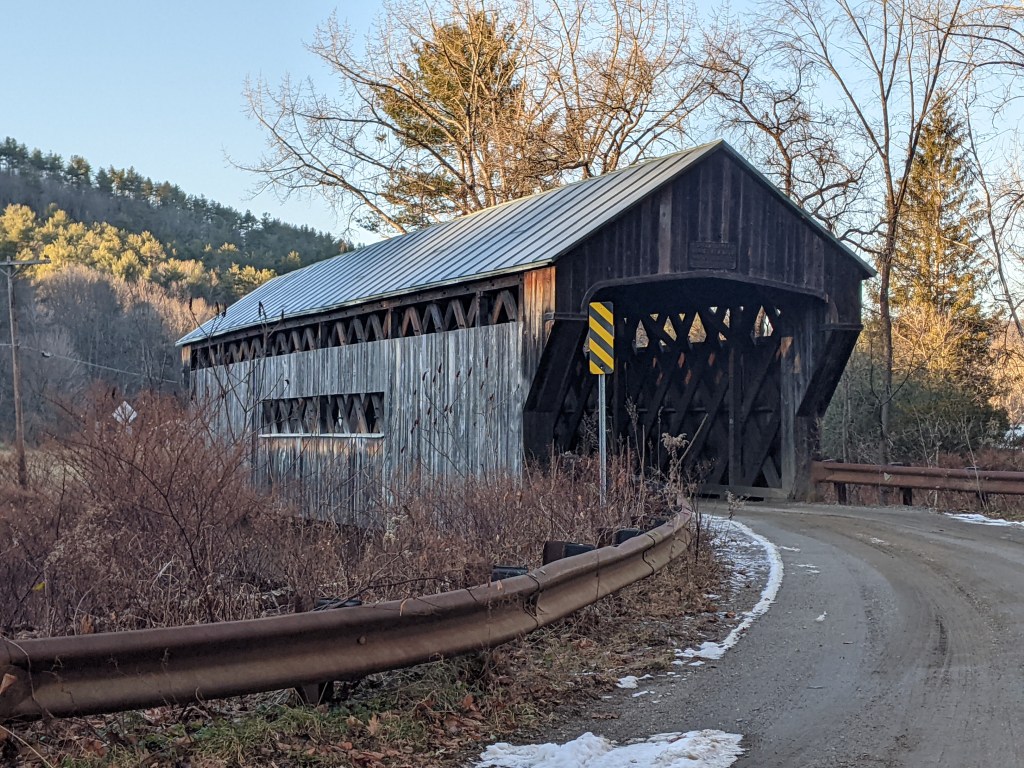
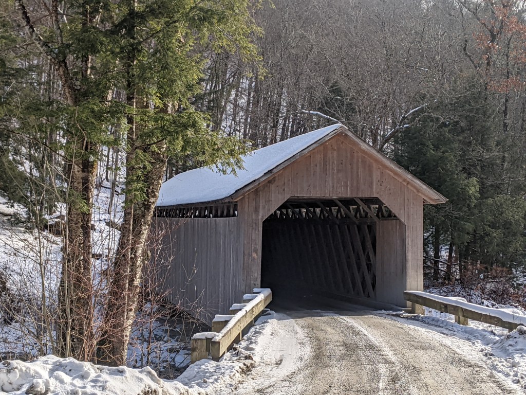
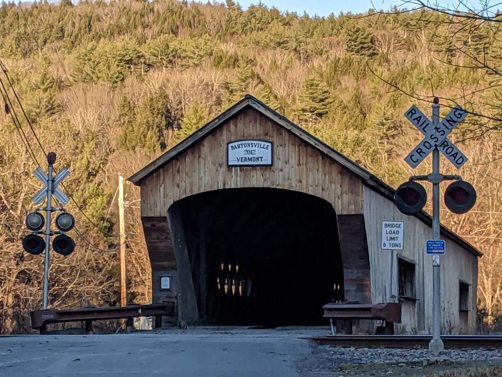
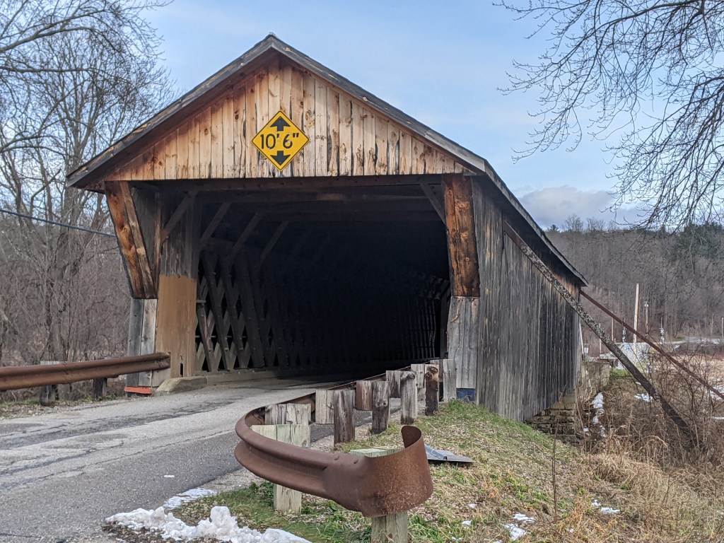
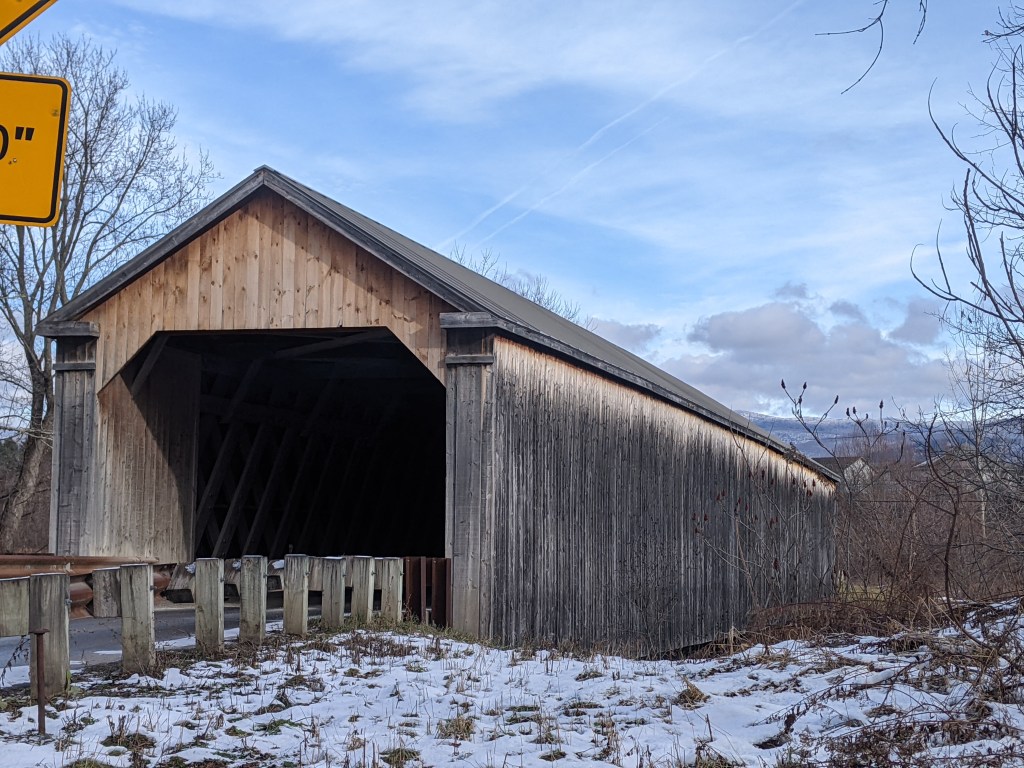
Oakland Bridges: Blvd of the Allies

The Blvd of the Allies was one of Pittsburgh’s grand public works projects from the 1920s. It rises from downtown, passing along the backside of Uptown and cutting through South Oakland before wrapping up in Schenley Park.

Four bridges enable the Blvd to make its mark on Oakland. Under normal conditions, only one of these bridges is pedestrian usable.

The road makes a flying leap into Oakland on the Boulevard of the Allies Bridge. On the South Oakland side, the Blvd enters a commercial corridor that begrudgingly gives pedestrians a place on a narrow sidewalk that abruptly begins (or ends) at the edge of the bridge. On the other side of the bridge, the Blvd is a mess of highway interchanges, so pedestrians are not welcome to utilize this bridge to go anywhere.

At the other end of the commercial corridor, pedestrians are invited to cross the Charles Anderson Bridge over Junction Hollow and into Schenley Park. (This bridge is also featured in Oakland Bridges – The Hollows.) However, once in the park, pedestrians are pushed away from the Blvd as it changes names and before it cruises through the Park.

The next two bridges are related as one is over the pedestrian route and one over the vehicular route to the recreational facilities of Schenley Park. These facilities include a pool, ice skating rink, disc golf course, tennis courts, and a track. The bridge over the pedestrian route is a small affair to cross over the pedestrian tunnel. The other is a slightly longer overpass over the two-lane segment connecting Panther Hollow Road and Overlook Drive. Neither the tunnel-bridge nor the overpass are open to pedestrians – except during the annual Pittsburgh Vintage Grand Prix, which I once took advantage of for some photographs.

Oakland Bridges: The Hollows

Oakland is a cluster of Pittsburgh neighborhoods east of downtown. It has the highest concentration of institutions and cultural amenities in the city. It is home to Carlow College, the University of Pittsburgh (Pitt), Carnegie Mellon University (CMU), multiple UPMC hospitals, the Phipps Conservatory (Phipps), Schenley Park (the second largest city park), and the Carnegie Institute complex (housing the Carnegie Museums of Art and Natural History, the main Carnegie Library, and the Carnegie Music Hall). Most of these as well as much of the commercial and residential parts of Oakland were built on a shelf. The hospitals, part of Pitt, and some houses climb the slope toward the Hill District. Some houses also spill over the edge of the shelf, down into the hollows.

Several bridges span the Junction and Panther hollows in Oakland. The Forbes Avenue bridge connects CMU to the Carnegie Institute complex and one of the commercial districts. The Schenley Bridge connects Pitt and the Carnegie Institute complex to the Phipps and Schenley Park. The Panther Hollow Bridge spans a second hollow to connect the Phipps with the rest of Schenley Park. The Charles Anderson Memorial Bridge carries the Blvd of the Allies over Junction Hollow. A fifth bridge without pedestrian access carries 376 over the hollow. This bridge can be partially glimpsed from the Anderson Bridge, but its presence can be clearly marked by the traffic’s rushing whoosh that carries up the hollow.

By the Forbes Ave and Schenley bridges, Junction Hollow has an industrial feel. The railroad is mostly exposed at these points (further down it is surrounded by trees, shrubs, and other overgrowth). There are also several parking lots and CMU houses some of its facilities functions along the hollow. By the Schenley Bridge, a massive electrical substation was recently constructed across from the historic (and active) steam factory.

The Panther Hollow Bridge provides a completely different feel as its hollow is 100% park. It is the only one of these bridges that does not cross over the railroad and is therefore the only one without a cage. A small lake with walking trail is visible on one side (with the railroad beyond a row of weeds). The other side overlooks a forested hillside and valley floor. Hawks and/or falcons can often be seen gliding over this hollow.

The Anderson Bridge overlooks Junction Hollow at its most parklike point, but it has a less peaceful feel than the Panther Bridge. A combination of the almost-highway Blvd of the Allies, the bridge’s height above the hollow, and its pedestrian fence make the bridge feel isolated from nature when walking across.

Rutland’s Bridge

While wandering around Rutland, Vermont’s third largest city coming in at around 16,000 residents, I found a bridge. Naturally, I walked across it. The bridge connects the worker housing on the flats to the cultural/civic center on the slope beyond which are the wealthier residences. In addition to overcoming the obstacle of the elevation change, the bridge spans the remnants of the formerly extensive rail yard much of which has been converted to a shopping center.

There was also a railroad bridge near the other end of the shopping center. By the time I found this bridge I was hungry, overcome by the humidity, and over a mile from where I was staying. A little farther on were some creeks that probably have bridges over them. I’ll have to look for those the next time I’m in town.

Keeping an Eye on Hazelwood Slope: Sep. 2021

Overview

Hazelwood is a neighborhood about 4 miles down the Monongahela River from downtown Pittsburgh. It is currently experiencing significant change, at least in the Hazelwood Green portion. The area that I’m designating as Hazelwood Slope is everything outside Hazelwood Green and the small residential enclave between the tracks and the river that I call Hazelwood Flats. The Hazelwood Slope contains the neighborhood’s commercial corridor, cultural and historical sites, and the majority of the neighborhoods’ residences.

What’s New

After my September 2020 check-in on Hazelwood, it seemed that changes in Hazelwood were happening at a slower pace than the other sites I’m keeping an eye on. So I decided to switch from a 6-month interval to a 12-month interval between visits. A few months ago, I saw construction vehicles and other signs of activity while driving down Second Ave through Hazelwood. I thought perhaps I was missing out on some activity. However, when I walked through the neighborhood this month, I couldn’t find any signs of recent demolition or recent construction.

An exciting project that is projected to start soon is the conversion of the former Gladstone School to affordable housing. There were subtle signs of site prep when I walked by this month. Construction is expected to start before the end of the year with an anticipated completion date in 2023.

The Photos

Second Ave
Hazelwood Ave & Other Sites

Hazelwood in the News

Funding from Bridgeway Capital, the Urban Redevelopment Authority, and the Pennsylvania Housing Financing Agency has been awarded for affordable housing projects in Hazelwood. Center of Life, a local non-profit, also received a major donation to support its mission of helping underserved K-12 students and their families in the neighborhood.

Inspired by the popular Friday fish fries in Pittsburgh, Hazelwood’s Community Kitchen launched a Friday BBQ series this year.


Locating Hazelwood Slope


Previous posts in series

Keeping an Eye on Hazelwood (across the tracks): Sept. 2020

Keeping an Eye on Hazelwood (across the tracks): Apr. 2020

Keeping an Eye on Hazelwood: Introduction


Open Streets Hazelwood Green

I was confused when Open Streets Pittsburgh announced that it was closing the streets in Hazelwood Green to cars and opening them to bicycles, roller skates, walkers, etc. Unlike the other locations they’ve done, not many cars use these streets and there aren’t any businesses on the site that people would come back to patronize after the festival.

However, it worked as a vehicle to increase awareness of the bike trail, plaza, and repurposed industrial buildings on the site. People who never or rarely come to Hazelwood, but come to Open Streets, came and participated. There were far more people than I’ve seen congregated in a single location since the beginning of the pandemic, which is also an exponential increase in the number of people I’ve seen in Hazelwood Green either pre-, post-, or during pandemic.

It was great to see the new plaza put to one of its intended uses as a concert venue with vendors on the paved portion. I arrived in time to grab some lunch from the tent for C&D’s Kitchen, a local Hazelwood restaurant, before finding a good seat to enjoy Jimmy Adler’s Blues Band and people watch. A young girl unconsciously stopped in her tracks to swing her hips to the music (not having the muscle coordination yet to do both). Across the green, a man kicked off his shoes to boogie on the grass.

I hope to enjoy many more such sights at events in this plaza.

Keeping an Eye on Uptown: Jul. 2021

Overview

Uptown is one of the many neighborhoods in Pittsburgh that experienced decades of neglect. For this neighborhood, the neglect was despite Uptown being sandwiched between Oakland and downtown, two places among the state’s strongest economic regions. Zipping through Uptown from Oakland to downtown on Fifth Avenue or from downtown to Oakland on Forbes Avenue, it is easy to overlook or dismiss the hodgepodge of ruined home foundations turning back to forest; scattered vacant lots, parking lots, and industrial uses; and the intricate architectural details on abandoned and renovated townhomes.

In recent years, new buildings started springing up here and there. Some of these new projects are the work of the two institutions in the neighborhood: UPMC Mercy Hospital and Duquesne University. Others are the work of a variety of commercial and residential developers. Two reasons for this recent investment are the proposed Bus Rapid Transit system, which will eventually run through the neighborhood, and the in-progress redevelopment of the Lower Hill, an adjacent neighborhood.

The Uptown community saw these changes coming and prepared. Between 2015 and 2017, the community organization Uptown Partners collaborated UPMC Mercy, Duquesne University, the City of Pittsburgh, and others to create the EcoInnovation District Plan and the Uptown Public Realm zoning district. The plan and new zoning district are intended to guide future development and leverage their economic investment for the greater good of the neighborhood. Ideally, this will reduce the number of those who will be left behind.

This blog post is part of an on-going series watching the changes in Uptown. Periodically, approximately every six months, I return to the neighborhood to take new photographs of the same areas. In addition, I include links to articles about the project that I’ve encountered since the previous post in the series. At the end of the post, there is a map showing the location of the neighborhood and links to the previous posts in the series.

What’s new

Development activity is picking up in Uptown. Walking around the neighborhood for this update required skirting closed sidewalks, uneven pavement, and construction staging of materials and equipment. The new activity includes:

  • PWSA’s (Pittsburgh Water and Sewer Authority) replacement of the watermain and lead service lines along Forbes Avenue
  • Evidence of demolition work on the long boarded-up Seneca Street rowhouses (image 3)
  • Demolition progress for the development of tech flex project that was briefly held up last year due to community concerns of gentrification (image 6a)
  • A new project for apartments and retail going up on 5th Avenue while the buildings around it appear to be preparing for renovation or demolition (image 8a)
  • Duquesne University’s next project to demolish and build on the site across the street from its newly rebuilt fieldhouse (images 21a & 22a)

The Photos

Uptown in the News & on the Web:

Next Pittsburgh reported on the start of construction for the new 51-unit apartment building on 5th Avenue (June 3, 2020), captured in image 8a above, and the opening of Duquesne University’s UPMC Cooper Fieldhouse (February 1, 2021), shown in image 22a above. The Pittsburgh Business Times shared what students will experience in Duquesne’s new College of Osteopathic Medicine (May 13, 2021) that is being built across from the fieldhouse (images 21a and 22a above).

Uptown Partners began to install free community wi-fi in the neighborhood (Pittsburgh Business Times, November 10, 2020).

And more federal funds have been directed toward the ongoing development of the Bus Rapid Transit system through Uptown to connect downtown and Oakland (Pittsburgh Business Times, June 11, 2021).

Locating Uptown


Previous posts in series:

Keeping an Eye on Uptown: Nov. 2020

Keeping an Eye on Uptown: May 2020

Keeping an Eye on Uptown: Nov. 2019

Keeping an Eye on Uptown: Introduction (November 15, 2019)

Moral Economics (September 1, 2019)

Beechview Bridges

Beechview is a neighborhood built on the crest of a hill and spilling down all the sides of the ravines and runs. It claims the steepest paved car “accessible” street in the US, if not the world. Traveling in almost any direction around or through the neighborhood includes an uphill portion. It is a place where anyone driving without chains ought to call in sick or request to work from home after a snow or ice storm to avoid sliding back down the hill when attempting to leave the neighborhood.

Bridges are used to create more level routes, spanning hillsides, runs, and dips. However, none of the two and a half bridges in the neighborhood are for cars. (The half bridge crosses the city boundary into the neighboring borough of Dormont.) The bridges are for the “T”, the local light rail system. Cars are left to manage the ups and downs as best they can. Pedestrians have access to one of the bridges, but otherwise, they are also left to manage the slopes as best they can.

The bridge with pedestrian access was constructed in the era of cages (see post). I am noticing a theme of completely enclosed pedestrian walkways found in association with major transit lines (ex. Beechview’s bridge, Graham Street Bridge, and the former pedestrian bridges over the East Liberty busway) while partially enclosed cages are found in association with roads and rivers (ex. Highland Park Bridge and the pedestrian bridge over Bigelow Blvd).

Keeping an Eye on the Lower Hill: May 2021

The Lower Hill is a notorious site in Pittsburgh, a scar on the city from the height of Urban Renewal. A vibrant (but poor and predominately Black) neighborhood was demolished in the 1950s so the City could build a cultural mecca centered on a Civic Arena, most of which ended up not being built and was left as parking lots.

Now that the arena has been demolished and replaced adjacent to the former location, the Penguins hockey team has the development rights to rebuild the Lower Hill, stitching back together the fabric of the city and reconnecting the remainder of the Hill District neighborhoods with downtown.

However, grand language describing the wonderful benefits to a city are part and parcel of any major development project, including the 1950’s Urban Renewal of the Lower Hill. Fifty years later, the Urban Renewal of the Lower Hill is rarely, if ever described as a good thing. In fact the current redevelopment is sometimes described as undoing the mistakes of that project. However, can the negative financial, social, and emotional repercussions of the original demolition and decades of disconnect be undone simply by reinstating (most of) the former street grid?

This blog post is part of an on-going photographic series to watch the redevelopment of the Lower Hill. Periodically, approximately once every six months, I return to the site to take new photographs. In addition, I include links to articles about the project that I’ve encountered since the previous post in the series. At the end of the post, there are links to all the previous posts in the series.

Lower Hill in the News:

A deep look at the Penguins development in anticipation of ground breaking later this year (January 13, 2021, The Undefeated)

Is the project moving too fast to make sure it is done right for the community? (March 15, 2021, Pittsburgh Post-Gazette)

Community questions if the first building is being rushed at the community’s expense (March 16, 2021, WESA)

Pittsburgh’s Equal Opportunity Commission approved the Penguins’ MWBE participation plan (March 18, 2021, Pittsburgh Business Times)

Penguins updated the community on progress of MWBE inclusion as ground breaking approaches (April 1, 2021, Pittsburgh Business Times)

The census line is moved to undo the Urban Renewal inclusion of the Lower Hill in the downtown census tract, but will this divert needed funds from the rest of the Hill District? (April 7, 2021, Public Source)

A major Black church was demolished as part of Urban Renewal while a nearby White church was saved from the wrecking ball, are reparations now possible? (April 14, 2021, Public Source)

Penguins propose a $5 million Opportunity Zone fund (April 16, 2021, Pittsburgh Post-Gazette)

The final plan presented to Pittsburgh’s Planning Commission for the new FNB Tower proposes not finishing the last block to reconnect Wylie Ave to downtown. This is a change from the guiding redevelopment plan and technically requires an amendment that the developer says will take too long. (April 20, 2021, Pittsburgh Business Times)


Previous posts in series:

Keeping an Eye on the Lower Hill: Dec. 2020

Keeping an Eye on the Lower Hill: Jun. 2020

Keeping an Eye on the Lower Hill: Jan. 2020

Keeping an Eye on Uptown: Introduction

Keeping an Eye on Penn Plaza – Apr. 2021

“@#$%&!” slipped out of my mouth when I was several blocks away from the former Penn Plaza site and I saw a hulking behemoth of a building looming high above the surrounding neighborhood. In it’s current state, the new development appears to be as tall as the Daniel Burnham apartment building on Highland Ave opposite East Liberty Presbyterian Church, which is much taller than any other structure remaining in the neighborhood besides the church. While I had seen the early drawings of the proposed development when I worked at the City, I was bowled over by seeing the actual size and how it has no relation to the surrounding neighborhood.

This has promoted me to look back at the process of how this project got approval from the city. What I have found so far has only prompted more questions. When a developer proposes a project that is in compliance with the zoning code regulations, there is not much the city can do besides ask “pretty please.” I had assumed that was what the story was here, but so far I don’t see how this project was in compliance with the zoning requirements. I’ll continue digging through the past records to try and wrap my head around the zoning approval for this project. In the meantime, below are photos of the current building progress and some news articles about the development since my last post.


Penn Plaza in the News

In a November 23, 2020, article WESA explores what the Mayor’s Office really knew before the eviction notices. WESA also produced a podcast on Land & Power to explore what happened and how in this East Liberty site.

Former Penn Plaza Residents are being given an opportunity to return to the neighborhood in the new Mellon Orchard Development as reported by ELDI (December 15, 2020) and the Post-Gazette (February 17, 2021).


Previous Posts in the Series

Keeping an Eye on Penn Plaza – Nov. 2020

Keeping an Eye on Penn Plaza – Aug. 2020

Greenfield Bridge

The Greenfield Bridge, formerly known as the Beechwood Boulevard Bridge, was originally built in 1922, demolished in 2015, rebuilt in 2017, and repaired in 2020. It was a classic case of waiting until the bridge was falling down before replacing it. To increase the lifespan of the original bridge, a second bridge was built underneath, and a net installed as early as the late 1980s to protect cars on the freeway below from the falling debris.

Yet it remained in that deteriorating condition for decades before being imploded in a grand ceremony between Christmas and New Year’s Eve 2015. The freeway was covered with tons of dirt, the bridge dropped onto this pile, and the debris cleared away before the highway was needed again for regular commuting. Many people (myself and my family included) stationed themselves on either hillside to watch. We picked a distant vantage point in Schenley Park where we had a great view of the dust cloud that resulted from the demolition.

Another grand ribbon cutting ceremony took place when the new bridge reopened in 2017. A part of the reason for celebration was that, similar to the rebuilding of Heth’s Run Bridge, the historical decorative elements of the bridge were restored or reinstated. The new fencing on the bridge also aimed for a more decorative feel compared to the previous cage-like fencing.

After all the ceremonies and splash around the new bridge, I was surprised to receive a press release three years later announcing that the bridge would be closed for a month to undergo repaving and other repairs. On the one hand, it was nice to see that a bridge was undergoing maintenance instead of being left to fall to pieces before being replaced, but three years seemed early to need this kind of maintenance. According to the Post-Gazette, the repairs were for issues identified in the final inspection before the 2017 reopening. These issues threatened to significantly shorten the projected 50-year life span if unaddressed. Now that those issues have been resolved, I assume it will be at least 50 years before the next press release about repair or renovation for this bridge.