Gingerbread Blue Mosque

Gingerbread Blue Mosque Blue Mosque

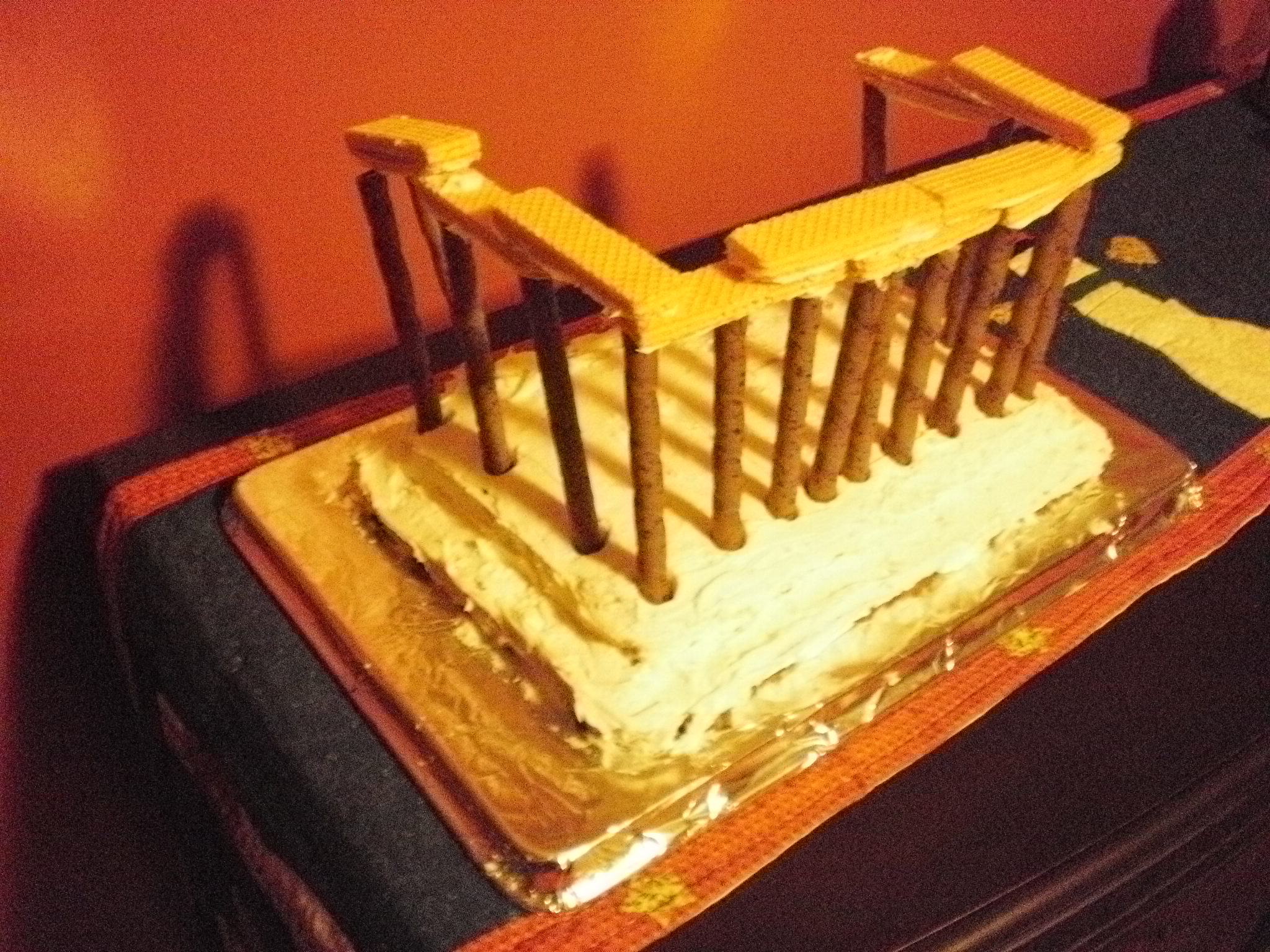
Figuring out how to design an accurate representation of the Parthenon out of cake and cookies (see post) was an intriguing task that set me on a new hobby of designing models of existing buildings out of deserts.  Beginning with my second Architectural Dessert Masterpiece, all my creations are based on buildings/structures that I have personally encountered in my urban explorations.

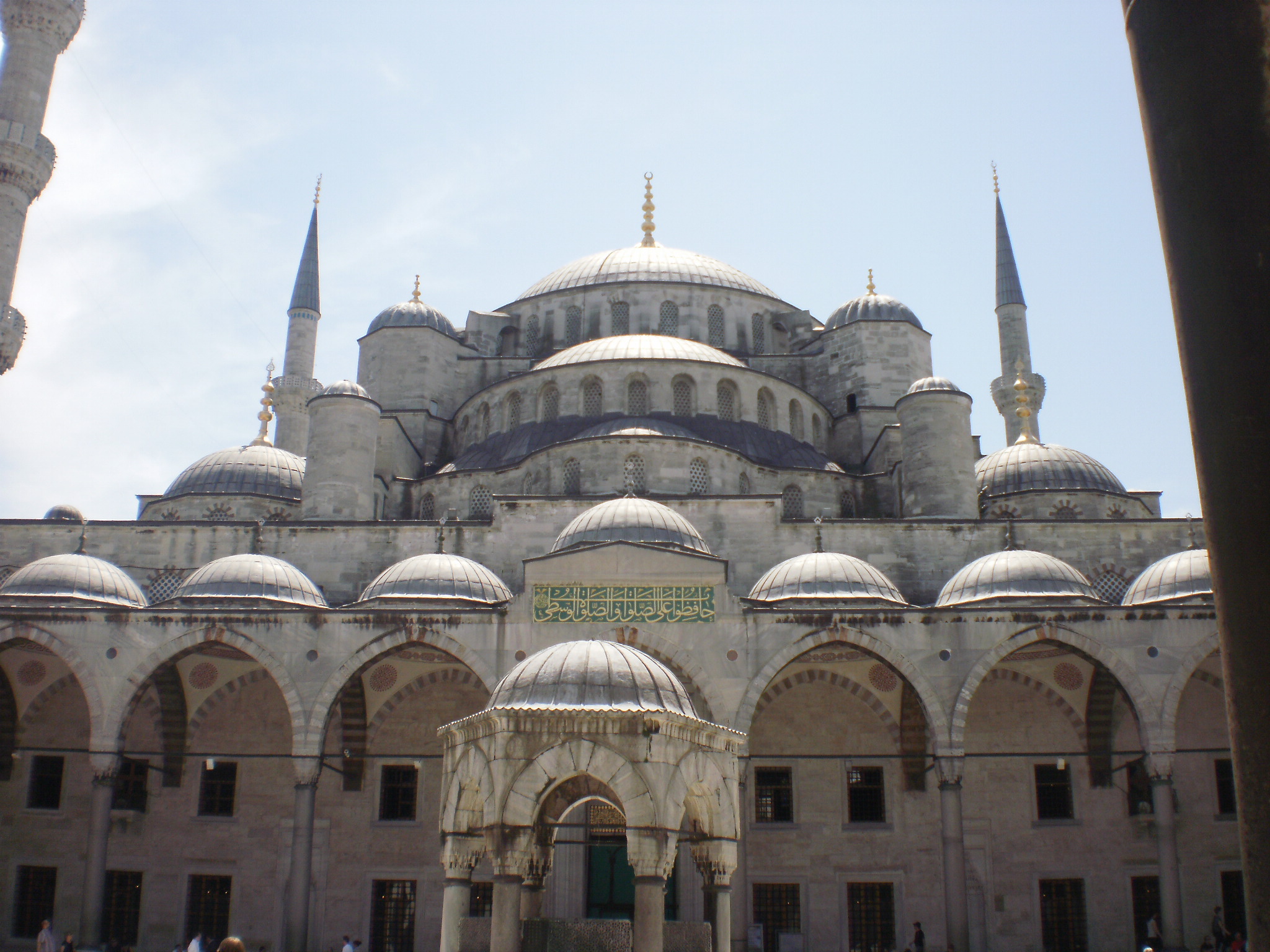
I created my second desert building in December 2011.  While eating the Parthenon the previous year, suggestions were put out about how to create other shapes and buildings such as using jello and creating round shapes.  I was particularly engaged by the idea of how to create a dome.  I had not figured out how to create a dome such as those on capital buildings in the US, but I thought I could create one that would be close to those on the mosques I visited in Istanbul.  I chose the Blue Mosque as a visually interesting structure that would require a diversity of desserts to create.

Gingerbread cookies seemed to be the best way to design the frame of the building given the variety of heights and shapes of the building.  I used sugar cookies for the larger domes and half domes.  I knew someone growing up who was able to create perfectly rounded sugar cookies, no matter how I try I have never been able to create the same effect.  My sugar cookies worked well for the medium-sized domes, but I had to put two cookies together for the larger domes.  M&Ms made great small domes–they were also the base unit that determined the scale of my model.  I think another reason why I chose to create a mosque was so I’d have an excuse to use the Pirouette cookies again, this time as minarets.  I love these cookies, but hardly ever get them.  Using my piping set, I was able to create pointed tops on the minarets and add balconies.

This was by far the most time-consuming Architectural Dessert Masterpiece to create (at least of the four I’ve made so far) because of having to design the required sizes and shapes for the gingerbread cookies and cutting them out and then also baking sugar cookies, which somehow always takes forever.  I also played with “whitewashing” the gingerbread walls, but the method I tried didn’t create the desired effect so I gave up on it.

Eating Architectural Dessert Masterpieces is also an interesting experience, as they often require creative thinking to destruct them.  With the Parthenon, I employed a karate-chop method for cutting through the wafers.  On the other hand, with the Blue Mosque a free-for-all of pulling it apart with your fingers seemed most appropriate.

Gingerbread Blue Mosque Blue Mosque

Parthenon Cake

Parthenon Cake

My hobby of creating Architectural Desert Masterpieces began about three years ago, when I was an AmeriCorps volunteer.  Searching for activities to do with my kindergartners in the after-school program, I somehow came across a recipe for making an Ancient Temple Cake.  While this was not at all feasible to do with my students, I thought it was an awesome idea and saved the recipe to try one day.

The following December, I decided it was time to try the Ancient Temple Cake.  By that point I was back in school and had taken a history of Western Architecture course, which included detailed discussions of ancient temples including the Parthenon.  When I pulled out the recipe, I decided it needed some improvements to make it a reasonable imitation of the Parthenon.  The directions were to bake a sheet cake, frost it, stick Pirouette cookies around the edge and top the Pirouettes with wafer cookies.  However, from my architecture course I knew that proportions were important as were the steps up to the temple.

I created a step to the temple but cutting off the edges, cutting them in half (height-wise) and reattaching the bottom halves to the cake body with frosting.  Then I added a number of Pirouette cookies based on the proportion of columns on the long and short sides of the Parthenon.  When I was done, I had a much better representation of the Parthenon in cake form than the recipe I started with.

Unfortunately, my cake temple aged rather quickly resulting in the collapse of the columns on one side.

Ruined Parthenon Cake

Pedestrian Bridges: Chicago

BP Bridge

There are two pedestrian bridges connecting to Millennium Park in Chicago.  The first I encountered was the BP Bridge.  I admired the undulating silver sculpture above as I walked past and was thrilled to discover it was a pedestrian bridge.  My excited was quickly crushed as the bridge was closed to traffic due to construction at the other end.  I realized that I have become quite addicted to bridge-walking.  I was on my way to see The Bean before renting a bike to ride along the lake, when seeing this bridge completely sidetracked me.  I had a desperate urge to walk a bridge.  Fortunately, there was another pedestrian bridge nearby and while it was not nearly as enticing, it had some interesting parts.

BP Bridge The Nichols Bridgeway

The Nichols Bridgeway connects Millennium Park with the Art Institute of Chicago.  Both ends had space-age-like toughs, which I assumed were supposed to be a fancy drainage system.  If their purpose is a drainage system, the upper end by the Institute has failed and been turned into a wishing well.

Lower Trough Upper Trough/Wishing Well

The part I liked best about this bridge was that while it looked like the surface was level, there were ridges or “speed-bumps” every few feet.  I wondered if these were merely artistic or if they had a functional value like reducing the slipperiness of the bridge during icy conditions.

Bumpy Walkway The Nichols Bridgeway

What is a Bridge? Chicago Edition I

Stetson Ave, Chicago, from the Hyatt

In July 2012, a few months into the height of my Pittsburgh bridge-walking, I pondered the definition of a bridge in What is a Bridge? Pittsburgh Edition I and What is a Bridge? Pittsburgh Edition II.  Asking what a bridge is may seem a little odd.  After all, it’s one of those things that you know it when you see it, right?  Yet, in walking bridges, I’ve discovered it really isn’t that simple.  In everyday life, the actual semantics of what a bridge is, is not important–you either cross it or you don’t and move on with your life.  But if you’re trying to walk as many Pittsburgh bridges as you can (as I am) or to count the number of bridges a city has to see which has the most of any city in the world (as others have), spelling out a clear definition of a bridge becomes important.  By the end of my previous posts on the definition of a bridge, it seemed like I had covered almost all the difficulties: is a bridge still a bridge if it no longer bridges anything? what’s the difference between a bridge and a ramp? how many is one bridge?….but then I went to Chicago and faced a new facet to this problem.

The issue Chicago brings up is best illustrated by the image above.  Is there a bridge in that picture?….No, right?….Try again.  If you walk past the buildings on the right, you get a new perspective on the seemingly solid ground you stand on (pictured below).

Discovering Ground Level on Stetson Ave
Looking Back Toward Hyatt on Stetson

Walking around on this street and the blocks around it, you may notice metal joints like those normally found only in bridges running across the roads and sidewalks.  You may also feel the ground bounce like a bridge as a large truck drives by.

Metal Joints across road and sidewalk on Michigan Ave
Metal joint across road on Columbus Drive

Are these roads, then, really bridges?  If no, what are they?  If yes, where does one bridge end and the other begin?  For example, is the Michigan Avenue Bridge across the Chicago River, visible in the back left of the image above-left, just a continuation of the Michigan Avenue road-bridge or is it a separate bridge?


Other posts in this series:

What is a Bridge? Pittsburgh Edition I (July 18, 2012)

What is a Bridge? Pittsburgh Edition II (July 27, 2012)

What is a Bridge? Chicago Edition II (February 1, 2020)

What is a Bridge? Bethlehem Edition I (July 1, 2020)

What is a Bridge? Bethlehem Edition II (July 15, 2020)

Manhattan Bridge: A Multimodal Link

The Manhattan Bridge

When I was planning my walk across the Brooklyn Bridge while in New York City last December, I noticed there was a bridge nearby called the Manhattan Bridge.  I decided to cross to Brooklyn by the Manhattan Bridge and return to Manhattan by the Brooklyn Bridge.  The Manhattan Bridge ended up being the more interesting of the two bridges.

Gateway to the Manhattan Bridge

I found my way from the subway stop to the Manhattan Bridge by following the way-finding signs for the bike lanes in the Lower East End.   This brought me to the left side of the bridge, where I was temporarily upset to see that pedestrians were not permitted to use the sidewalk on that side of the bridge–it was dedicated to two-way bicycle traffic.  I was concerned that I was not going to be able to walk across this bridge and instead would have to cross the Brooklyn Bridge twice (I try to avoid walking across a bridge just to walk back across it; doing so gives me a sense of pointlessness).  Luckily, there are sidewalks on both sides of this bridge (from walking Pittsburgh bridges I know not to assume that bridges have sidewalks on two sides) and the sidewalk on the right side is dedicated to pedestrians.

I suggest that NYC puts up a sign on the bicycle side to direct pedestrians to the other side, which might help encourage pedestrians to follow the traffic directions set up on this bridge–I watched a pedestrian ignore the bicycle-only signs to cross the bridge on the bike lanes.

The Pedestrian Side

This bridge is the most multimodal bridge I have walked with the bike lanes on one side, pedestrian way on the other, and the subway and roadway in between.  While I approve of this welcoming of alternative transportation methods, I am not sure about placing the pedestrians next to the subway tracks.  This does give a barrier between the pedestrians and the noise of the cars, but instead, the pedestrians have to deal with the noise of the subway, which while it is less constant than the cars, it is a little more startling/disturbing.

The Manhattan Side The Brooklyn Bridge

The neighborhoods the Manhattan Bridge links had some similar physical elements, but are clearly used by different populations.  The populations on both the Manhattan and Brooklyn sides use their rooftops, but for different purposes.  On the Manhattan side, the rooftops were covered in graffiti, while the Brooklyn rooftops had new additions and places to sit.  There were also parks on both sides of the East River.  However, the Manhattan side only had a baseball diamond while the Brooklyn side had a carousel and a pirate-ship playground.

Manhattan side park

Carosel Pirate Ship Playground

What intrigues me most about the Manhattan Bridge is that I had never seen or heard of it before and yet it is the bridge shown in the background (multiple times) in the Doctor Who episode “The Angels Take Manhattan.”  Based on my walk on the Brooklyn and Manhattan Bridges, it looks like these shots were taken on the Brooklyn side of the river, in which case it seems like it possible to get the Brooklyn Bridge in the background instead as these two are close together on that side.  To me the images of the Brooklyn Bridge say New York, while (at least before I walked it) images of the Manhattan Bridge just say a place with a bridge and hence water.  I wonder if the Manhattan Bridge is better known in the UK than in my circle?

View like that used in Doctor Who