


Inspired by my post from this summer, I decided to start a photographic series of Pittsburgh’s Uptown neighborhood. This neighborhood is a hodgepodge of abandoned and renovated townhomes, parking lots, car-oriented businesses, corner stores, industrial uses, and new construction residential buildings. It is predicted to be on a tipping point from being mostly ignored to experiencing intense growth fueled by activities in and around the neighborhood. These activities include:
As these projects move forward, there will likely be more investment and changes to Uptown. This photographic series is intended to capture these changes by revisiting the same sites at regular intervals over the next several years.
In the coming months, I intend to release two related series to record the progress of the CAP and the Lower Hill redevelopment.
Amid writing my posts about how the wealth gap manifests itself in the built environment and the morality of unequal economic investment in cities, I took another trip to Chicago. I spent most of my stay in the downtown areas within a mile of Grant Park. I love the old stone buildings, established green parks, ornate fountains, and modern glass skyscrapers with interesting architectural embellishments. Yet this trip, I felt hypocritical as I walked around soaking it all in. All these elements that I enjoy are the result of significant financial outlay that I know is not evenly distributed throughout the city. So where was my moral indignation at this display of deeply entrenched wealth unequally spread?
Chicago’s display of wealth isn’t gaudy like Tijuana or Las Vegas. The message I absorb in places like those with their flashing lights is “come on in, so we can suck all the money out of your pockets.” Chicago businesses identified their presence on the street with regular signs leaving it up to the passers to decide whether to engage.
One bar did add a layer of enticement to their sidewalk advertising. I was searching for a place for dinner, with this bar in mind as the one that looked most appealing from Google maps. I was looking around to see if there were any other better options. The smell of the burgers from this first bar convinced me that it was the best option in that vicinity. It was only after I had sat down and ordered that I realized the smell wasn’t coming from the open window, but rather it came from pipes pumping the kitchen smells to the sidewalk. Still it was a subtle inducement and unlike flashing lights it did not have a nefarious undertone.
By pumping out the smell to the sidewalk, it also felt indiscriminate. Anyone passing was invited to enjoy. This was unlike my experience in Cardiff where if I couldn’t afford the items in the business, I felt I shouldn’t be walking past in the public space. I never felt like I didn’t belong in Chicago. There were economic barriers to certain experiences, but those places that I encountered still did not feel exclusionary. One example is the lounge on the 96th floor of Chicago’s Hancock Building. The stunning views are only accessible to those who can afford a $17 cocktail, but those who can afford one only once in a blue moon were just as welcome as those who can afford one or more every night.
In Chicago, I never saw that strong line, as in Tijuana and Cardiff, that divided those with and those without financial resources. Everywhere I went, there was a mix of people with different economic statuses, skin colors, and first languages. This diversity gave me the feeling that anyone is welcome to enjoy the well-maintained investment in public spaces with or without hitting a minimum financial threshold.
The strongest impression from my last trip to Cardiff was the feeling that it is morally wrong to invest heavily in touristy neighborhoods while skipping the neighborhoods of the residents. Tourists may provide a bigger return per touch point, but residents have many more touch points (including voting). Perhaps I have become jaded since that trip, but I now accept that economics and morals rarely work together.
Pittsburgh’s Uptown neighborhood is trying a different approach to see if economic investment can be leveraged for the greater good. Uptown experienced disinvestment and decay for decades, despite being located between and within walking distance of Oakland and downtown, two of the largest economic engines in the state. Not to mention the main roads connecting these prosperous and growing areas run directly through Uptown. Zipping down Fifth Avenue from Oakland to downtown, it is easy to overlook or ignore the ruined home foundations turning back to forest, the wide-spread vacant lots and parking lots, and the intricate architectural details on the remaining old structures.
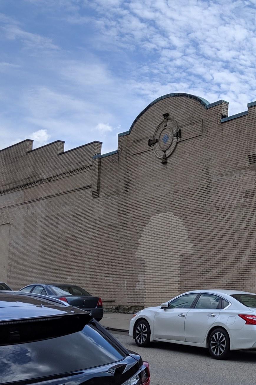
The bland brick and glass facade on Fifth Avenue identifies this building as another mid-century warehouse. Turning the corner, the decorative parapet wall and bricked over arched opening tell the story of an older, more interesting building.
One such structure was one of the many movie theaters dotting the city in the 1920s. In the 1950s, the adjacent buildings were demolished, and an addition was added to the theater to turn it into a storeroom. After a time as a plasma center in the 1980s and 1990s, the building sat vacant and dusty for many years. Now, it is undergoing renovations for its next life. This is just one of the many signs that investment is coming to Uptown.
The community of Uptown that held on through the economically rough times prepared for this moment. In collaboration with many partners, including local institutions such as Duquesne University and UPMC Mercy as well as the City of Pittsburgh, the community created a new neighborhood plan. This designated Uptown and West Oakland as an EcoInnovation District. One of the first actions from this plan developed a new zoning district, the first progressive zoning district in Pittsburgh. The goal of the plan and the zoning district is to leverage the coming economic investment to create an inclusive and environmentally sustainable neighborhood.
It will be interesting to watch this neighborhood over the next few years to see if the plans are successful at introducing some moral components to the economic investment.
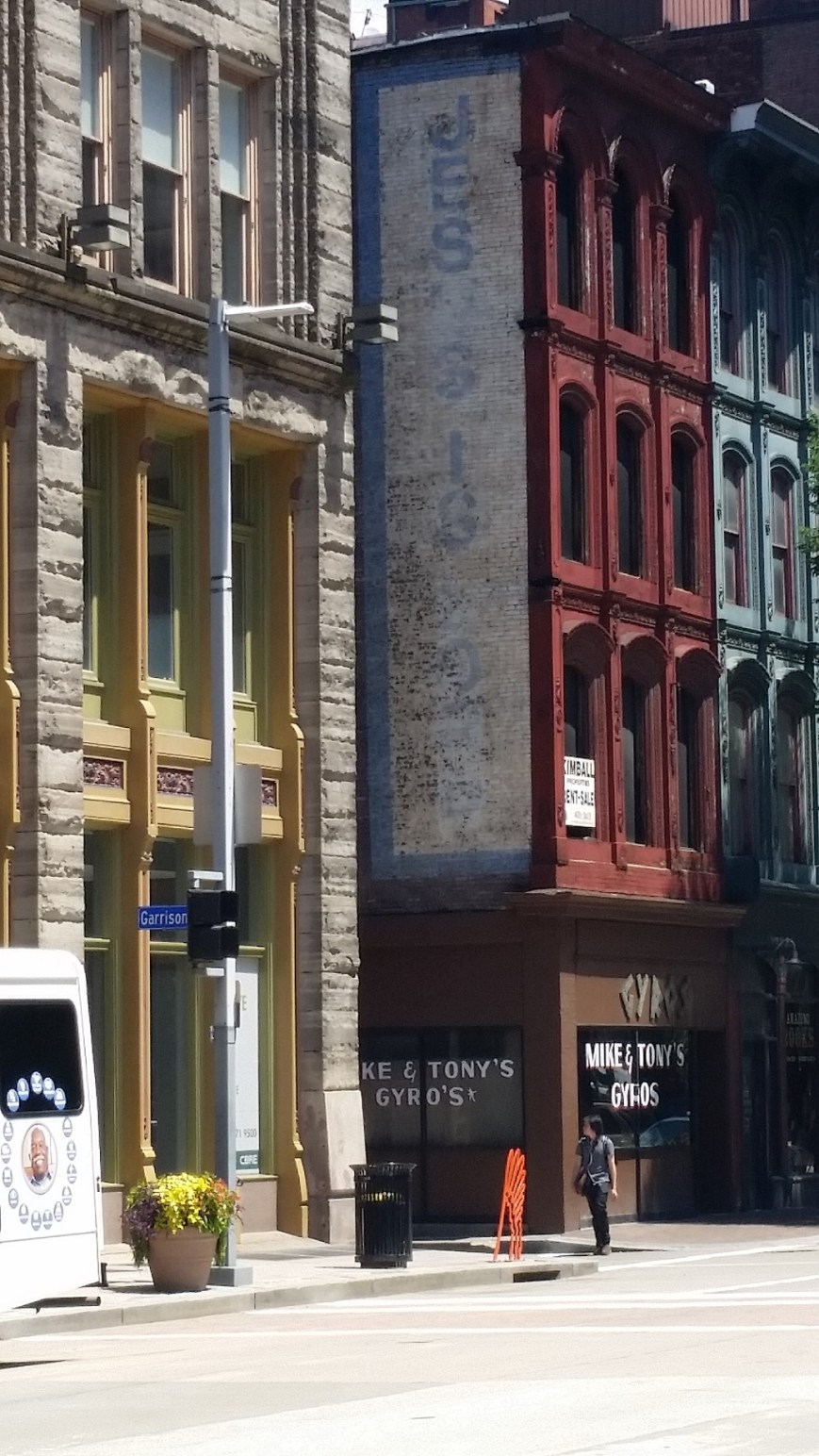
Once upon a time, signs painted on the side of buildings proliferated in Pittsburgh. Over the decades as these types of signs went out of fashion, many were left to fade with time. Remnants of these signs still cling to several buildings. Some signs are faded but legible while others only show faint traces of having been there.


These signs tell a story of the history of the city. Is it a story worth preserving? If so, what is the appropriate way to preserve it? Should these signs be refreshed so that they continue to live on? Or should they be left alone to continue to fad to show their decline from favor? Yet, there appears to be renewed interest in the hand painted sign. (This article is one of several about a niche of successful hand painted sign artists.) Maybe as these buildings are renovated, some of these signs will be refreshed with a modern take.

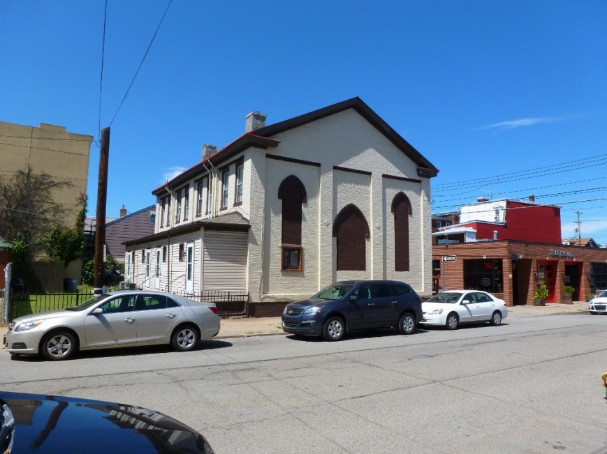
This is a fascinating structure I discovered on the South Side Flats. A friend and I were going around the neighborhood looking at adaptively reused church buildings. While going from one building we knew of to another location, we stumbled upon this building. From what I’ve pulled together so far, this building was built sometime between 1876 and 1884 as four rowhouses. In 1926, the Second Greek Catholic St John the Baptist Church of the South Side purchased the property. The deed described the structure as four 4-room houses. When the Second Greek Catholic St John the Baptist Church sold the property in 1959, the deed described the property as four 2-story brick party wall houses.

However, when you look at the side of the building facing 23rd St, it appears that at one time, this property was used as a church. The middle of the three boarded up openings on this side looks like it used to be a door for an entrance into a church that has been partially bricked up. From this I assume that while the Second Greek Catholic St John the Baptist Church owned the property, they renovated to use as their place of worship with a main front door and two windows.
I look forward to learning more about this structure and its history. I suspect there is an interesting story that connects this building to the 1st St John the Baptist Greek Church which is still in operation at the corner of E Carson St and 7th and the 2nd St John the Baptist Greek Church that set up just down the block at 615 E Carson St before moving to Jane St. From the pieces I’ve found so far there was a severe split in the South Side congregation that involved boycotts and arrests of arguing members and former members. I’m not sure yet how this rowhouse/church may have fit into that struggle.
Heth’s Run Bridge, the first bridge I posted about in my Pittsburgh bridges project, is scheduled to be replaced by the end of next year. The notice to proceed was expected to be issued last week with construction beginning on Sept. 24 with the installation of a temporary road around the bridge, through the zoo’s parking lot. According to the schedule that was passed out at a community meeting at the end of August, the bridge is expected to close with all car traffic being diverted to the temporary road on Nov. 1st. Due to the turning radius constraints with the temporary road, trucks will not be permitted and will instead be by way of the Highland Park Bridge, Route 28 and the 62nd Street Bridge. If all goes according to schedule the bridge should reopen to all traffic on October 1, 2014. Additional road work will continue through October. After final inspections, the project is expected to be officially completed by December 8, 2014.
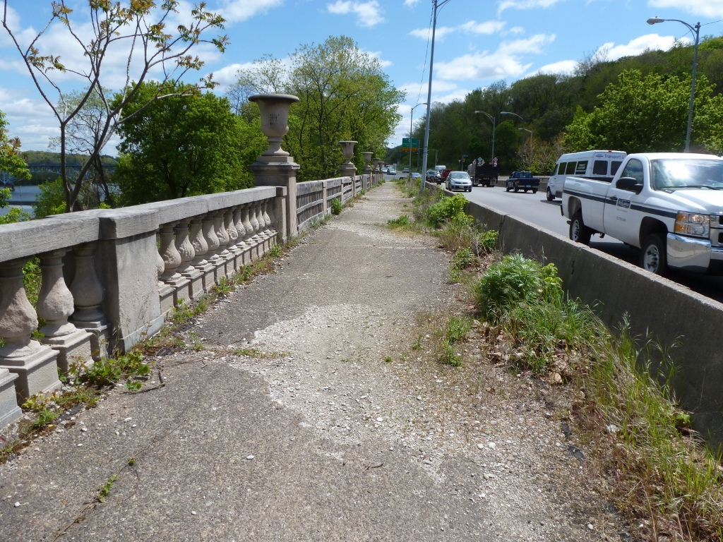
This is a PennDOT project expected to cost over $18.5 million and is definitely needed. As I discuss in my Heth’s Run Bridge Part II and Highland Park Bridge posts, the sidewalks here are in desperate need of repair and the proportion of sidewalk to road across the bridge is at least 50 years out of date. All this is going to be addressed in the reconstruction. The new bridge is going to have two lanes in each direction to match the roadway on either end. Additional features of the new bridge will be decorative railing, period lighting, entrance pylons, and “architectural features on the abutments with form liners” (which I believe refers to new urns). At the community meeting, it was mentioned that the current urns will be saved and kept in a warehouse until a new home is found for them.
In addition to the bridge, about 870 feet of Butler Street are going to be reconstructed including sidewalks. My understanding is that this is the part of Butler from the Heth’s Run Bridge to the ramps of the Highland Park Bridge, which should take care of my complaints about the condition of the sidewalk for those of us trying to cross the Highland Park Bridge without a car. This should also clear up the confusion for the outbound traffic of whether this part of the road is one lane or two as the plans include removing the “kink” from the existing alignment.
New signals and ADA ramps will be installed at the intersections of Butler with One Wild Place and with Baker Streets.
Another major part of the project is the excavation under the bridge to an elevation of 762. According to GoogleEarth, the bridge is at an elevation of 800 ft. I’m not sure if this will restore the bridge to its exact historic height, but it will be close (see the photo of the previous bridge from 1912). This will also pave the way for connecting this area to the proposed Allegheny Riverfront Green Boulevard project.
This project will no doubt cause some inconveniences during the construction process, but the construction of the temporary road will significantly cut down on this even though it adds over a month to the process. Imagine instead, everyone having to go on the truck detour or all the Zoo traffic coming down Morningside Ave and Baker Street instead of One Wild Place and Butler Street. That would be a true nightmare. Thank you, PennDOT and the Pittsburgh Zoo & PPG Aquarium for the temporary road. Thank you, PennDOT and any other funders, Sen. Jim Ferlo, Rep. Dom Costa, and anyone else who had a hand in helping bring about this long overdue project.
I can’t wait to walk over the new bridge when it’s finished!
More information about the project including the design of the temporary road can be found here: http://morningside-pa.org/wp-content/uploads/2013/08/hethsrunbridge.pdf
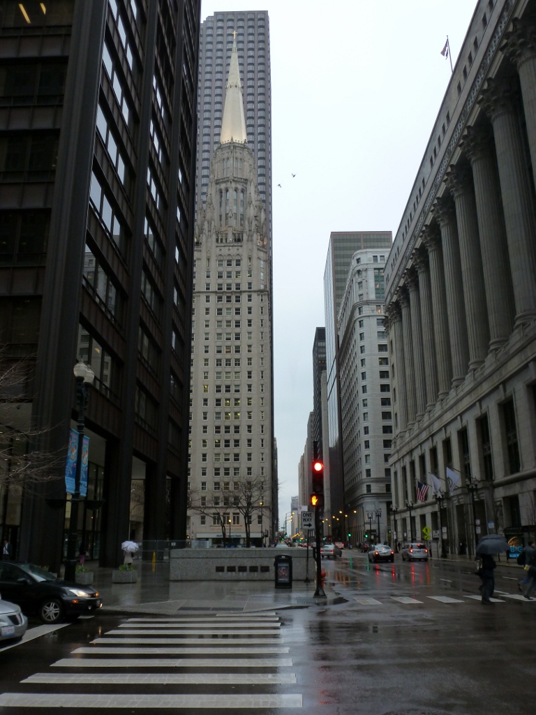
Everything in Chicago is stretched–even churches. My eye was caught by this building as I looked to cross a street in Chicago and saw the steeple on top of this skyscraper a couple blocks down. I was very confused at first, trying to figure out why an office building had a steeple on top of it. Then I saw the name of the church, First United Methodist Church, carved into the side of the building. The only other indication on the exterior visible from a distance that suggested the religious use of the interior was the doorway.
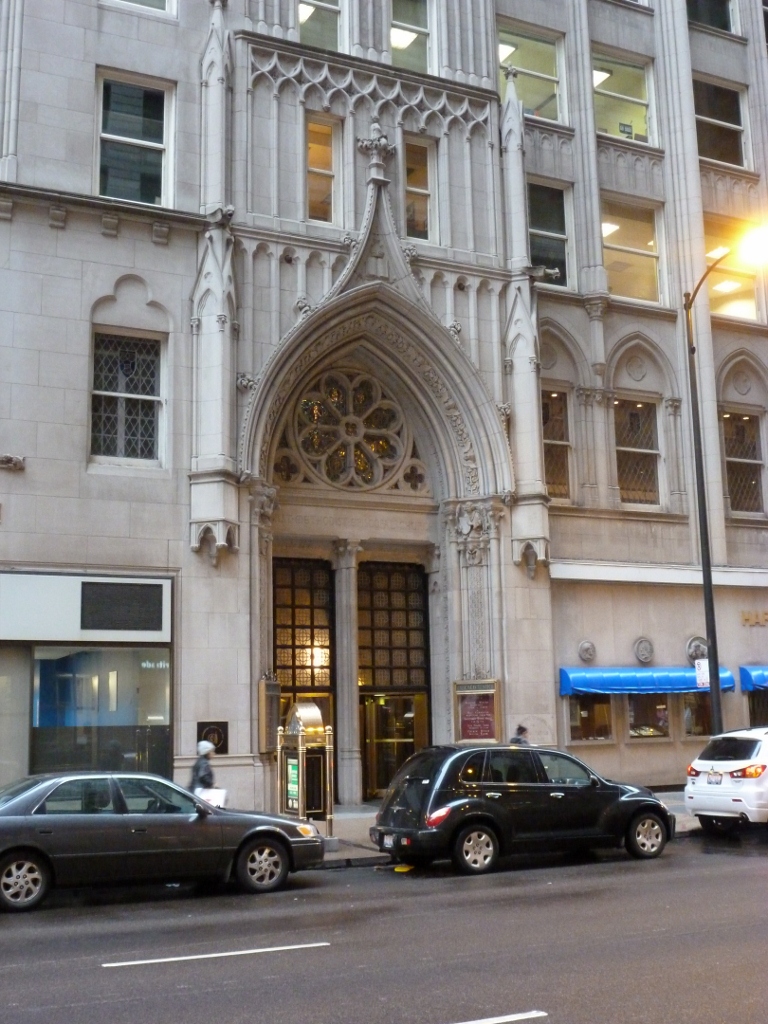
This building is also known as the Chicago Temple. The congregation was founded in 1831 and has been worshiping at this site since 1838. The current building was built in 1924 and has 23 floors.
One of my souvenirs from Chicago was the book “City of the Century” by Donald L. Miller, which describes the history of Chicago up to the 1893 World’s Fair. So it doesn’t talk about the building of this church building, but it does describe the building of the Auditorium–Chicago’s multipurpose Opera House. The book notes “there was no government support of the arts in the United States, so the Auditorium would have to pay for itself” (361). As a result the theater was enclosed in a office/hotel complex.
It seemed like there might have been similar thinking in the design of this church building–as real estate was expensive downtown, covering the church with office space could help it afford its location. However, if that is why the building is mixed-use, it was not inspired by the Auditorium, which was built in the late 1880s. According the history page of the church’s website, there has been a multipurpose church building on this site since 1858. The first one was a 4-story structure with stores and businesses on the first two floors and the church above.
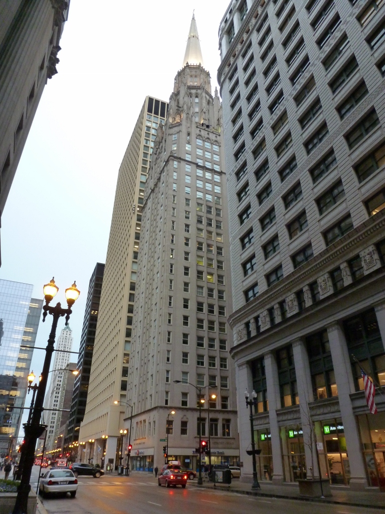
The new building has a two-story sanctuary on the first floor. Accounts differ as to how many this can hold (500, 1000, 1200 people). The second floor has another smaller sanctuary. Floors three and four hold the accessory rooms–classrooms, meeting rooms, etc. The parson’s house is also located in the building. The remaining floors are office space. The crowning jewel, is a small chapel underneath the steeple.
I regret that I did not take the time to stop and investigate whether I could explore the inside of the building. As I was focused on a specific task when I came upon the building, I did not even think about trying to see inside. If you are interested, I found a YouTube video that shows what I take to be the first floor sanctuary and the small chapel under the steeple.

As I was walking down Penn Avenue this week, I stopped to take this picture before it was gone forever. Pittsburgh is joining the ranks of cities that use multispace meter systems. The city’s individual parking meters are slowly disappearing as they are replaced by the multispace system. Yet even before the transition began, Pittsburgh’s parking meters were suffering. A complete row of intact meters marching off into the distance, such as those pictured, has been a rare sight in the city for years. Usually there are at least a few with their heads chopped off or their stalks bent. On close inspection, this row did have graffiti on many of the heads and at least one meter was out of order. However, in the spring sunshine, these meters looked almost pristine with their gold heads gleaming.

